Rediscovered! The Land of Geshur, Moshe Kochavi, Timothy Renner, Ira Spar and Esther Yadin, BAR 18:04, Jul-Aug 1992.
 Bible and Beyond
Not without some justification did Absalom arrange the murder of his half-brother Amnon. Amnon had raped Absalom’s sister Tamar. Nonetheless, fratricide among King David’s sons was not to be countenanced. After Amnon’s murder, Absalom fled—to the land of Geshur (2 Samuel 13-20–38), where he knew he would be safe. His mother Maacah was a Geshurite princess (2 Samuel 3-3); Absalom found refuge with Talmai, king of Geshur, his maternal grandfather. There he remained for three years.
David then recalled Absalom from exile. Once again, Absalom took up residence in Jerusalem, where he encouraged discontent and prepared a coup d’etat in order to seize his father’s throne. The rebellion ended with Absalom’s death, after which David uttered his famous lament, “O, my son! Absalom my son, my son Absalom! If only I had died instead of you! O Absalom, my son, my son!” (2 Samuel 18-33).
The short, tragic story of Absalom provides us with a glimpse into the political world of the early tenth-century B.C.E.a monarchy. Why had David found it advantageous to marry a Geshurite princess? We may be sure that this union, like most royal marriages in the ancient Near East, was for diplomatic purposes- It assured David of military and political support at a time when he was not yet king of a united kingdom comprising both Israel and Judah.
Who were the Geshurites? And where was their country located? We know the geographical location of Geshur from various passages in the Bible (Numbers 21-33–35; Deuteronomy 3-1–14). Moses, after taking the Israelites out of Egypt and across the Sinai, successfully led them in battle against the kings of Transjordan (Numbers 21-21–35; Deuteronomy 2-19 Deuteronomy 3-13). But the descriptions of these victories—over Sihon, king of Heshbon (today Hesban, in Jordan), and Og, king of Bashan (today in southern Syria) state that the Israelite conquest of lands east of the Jordan did not include the Geshurites. A short notice in Joshua makes this explicit-
“The Israelites failed to dispossess the Geshurites and Maacathites, and Geshur and Maacah dwell among the Israelites to this day” Joshua 13-13).
The Biblical texts show that we should look for the Geshurite homeland west of the fertile plains of the Bashan and south of Mt. Hermon. This would put Geshur east of the Sea of Galilee, in what today is called the southern Golan. Most of the area consists of a volcanic plateau rising some 1,500 feet from the narrow but fertile coast on the shore of the Galilee.
Modern archaeological research in the Golan began soon after the Six-Day War in 1967. This work at first concentrated only on the prehistoric, Roman and Byzantine periods. In 1987, however, we began the Land of Geshur Archaeological Project in an effort to better our understanding of the region’s settlement patterns and socioeconomic processes during the Biblical period, that is, the Bronze and Iron Ages. We especially wished to examine the material evidence for several important ethnic groups known to have inhabited or influenced the region in ancient times. In addition to the Geshurites and the Israelites themselves, these peoples included the Arameans whose powerful state controlled the Golan during the ninth century B.C.E. and afterwards.
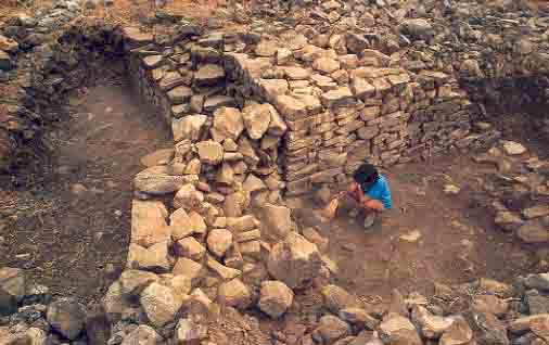
We conceived of the project as a regional effort, not just a one-site project. No major tell had been identified as a multiperiod site with sustained occupation, and no site in Geshur seemed to have served continuously as a strong, urban center of government. Therefore we chose, for detailed investigation and study, several key sites from different periods- Rogem Hiri, a megalithic site consisting of a huge stone cairn—a heap of boulders covering an above-ground burial chamber—surrounded by several concentric stone walls; Mitham Leviah, a large Early Bronze Age (3300–2250 B.C.E.) city with fortifications; Tel Soreg, first settled in the Intermediate Bronze Age (2200–2000 B.C.E.); Tel ‘En-Gev, the largest Iron Age II (1000–586 B.C.E.) site in the Golan; and Tel Hadar, an Iron Age I (1200–1000 B.C.E.) and Iron Age II fortified stronghold located, like Tel ‘En-Gev, on the shore of the Sea of Galilee.1
In “Mystery Circles,” in this issue, Yonathan Mizrachi describes the exploration of Rogem Hiri. In this article, we will focus primarily on sites dating to the second and early first millennia B.C.E.- Tel Soreg, Tel Hadar, and Tel ‘En-Gev. Before we do, however, a word about Mitham Leviah, our other key site.
Mitham Leviah (“The Enclosure of the Lioness”) is a half-mile-long site situated on a high spur overlooking the Sea of Galilee. A high, broad stone wall separates it from the rest of the Golan plateau; several hundred feet behind this is a second, similar wall. Since no other remains of buildings could be seen, the site was categorized—like other, similar sites in the southern Golan—as an “enclosure,” a large corral for shepherds and their flocks. The Geshur Project excavation, under the field direction of Lipaz Vinitzki of the Open University, Tel-Aviv, revealed that Mitham Leviah was actually a large, densely populated city that flourished during the entire Early Bronze Age (3300–2250 B.C.E.). The outer and inner defensive walls had well-constructed gateways aligned on the same axis. The city met its end through enemy attack- In their last phase both gates were blocked with stones to strengthen their defenses, and the expedition found many jars lying shattered on the floors of domestic buildings. If the results from Mitham Leviah are valid for the other “enclosures,” then the Early Bronze Age emerges as the most vigorous and impressive civilization that existed in the southern Golan prior to the Roman-Byzantine period.
Now let us take a closer look at the other key sites of the Land of Geshur Project. Tel Soreg is located on the crest of a hill overlooking the valley carved out by the ‘En-Gev River as that stream descends steeply from the Golan plateau to the Sea of Galilee. The site is small—less than an acre—but the presence of several springs watering lush vegetation nearby made it an ideal spot for early settlers. Excavation work begun in 1987 showed that the site was first inhabited during the Intermediate Bronze (2200–2000 B.C.E.) period (also called Early Bronze IV by some). The first inhabitants of Tel Soreg dug shallow pits into the white limestone rock on which they built their huts. They also cut deeper into the rock face in order to create caves for shelter during the winter. Pottery sherds indicate that the site continued to be occupied in the Middle and Late Bronze periods (2000–1200 B.C.E.). A dromosb burial cave cut into the rock on the site’s northern slope yielded especially well-preserved pottery from both phases, but unfortunately most of the architectural remains had eroded away.
Fragments of collar-rimmed storage jars indicate that the site continued to be occupied during Iron Age I (1200–1000 B.C.E.). The first fortification walls at Tel Soreg were not built until the ninth or eighth century (Iron Age II), when the region was under the control of the Arameans of Damascus.2 The stronghold was a small one, about 60 feet across, and occupied the northeastern corner of the site. But artifacts such as mortars, pestles, grinding stones and rock-cut, stone-lined silos clearly underscore the agricultural nature of this Iron Age II settlement.
The tell continued to be continuously inhabited until the Hellenistic era, and a bronze standard or finial in the shape of a predator similar to a jackal may date to this period. But when the nearby towns of Hippos (Sussita)c and Afeka were built during the late Hellenistic period, the small village at Tel Soreg was abandoned forever.
In 1987 the project also surveyed and began the excavation of Tel Hadar. The ancient name of the site is unknown.3 Astride a branch of the major international trade route that led from the Mediterranean coast to southern Syria and more northeasterly points, Tel Hadar is a 4-acre mound located on the eastern shore of the Sea of Galilee a few miles north of ‘En-Gev.
At Tel Hadar, occupation during the Middle and Late Bronze Age is indicated by the presence of potsherds from these periods. However, we have not yet had the time or resources to explore these Bronze Age strata. The earliest Iron Age settlement at Tel Hadar (designated stratum II) dates to Iron Age I (12th–11th century B.C.E.). A later stratum (stratum I) dates to Iron Age II (ninth-eighth century B.C.E.).
In Iron Age I, Tel Hadar was protected by two massive, concentric defensive walls, the remains of which were visible on the surface even before we began our work. The outer wall, running along the foot of the mound, is over 12 feet thick. The inner wall, located halfway up the slope of the mound, about 65 feet from the lower wall, is nearly 10 feet thick. Built of basalt, the stone portions of these walls probably rose about 15 feet above the ancient ground level. In keeping with city-building traditions in the ancient Levant, the upper portion of these walls would have been constructed of mudbrick; it probably added another 12 to 20 feet to the height of the defenses. The impression we get of Tel Hadar during this period is that of a powerful stronghold with security arrangements rather like those of a medieval castle.
The plan of Tel Hadar’s defensive walls is in itself unusual for this part of the Near East. For one thing, circular fortification walls for towns are unknown at Iron Age II Israelite sites, although they are paralleled by a group of nearly contemporary neo-Hittite centers in northern Syria and Turkey. For another, the gateway through the inner defensive wall on Tel Hadar’s eastern side has a very unusual arrangement- a 10-foot wide opening, flanked on one side by a 3-foot thick pier and on the other by a wall bending inward at an angle to form a distinctive “snail-mouth” entrance.
In the destruction debris of this gateway, we found basalt bowls, a large basalt basin and an undecorated orthostat.d We also uncovered two legs of a very finely carved basalt tripod bowl. These legs are in the form of stylized animal feet. Stylistically, this object is without parallel from sites in Israel and probably reflects Phoenician influence. The exemplary quality of the workmanship suggests that the population of Tel Hadar during Iron Age I included an elite who valued—and could afford—luxury items.
In the summer of 1990, we found a second orthostat lying on the surface in an unexcavated area of the tell. Orthostats are usually associated with royal architecture. When combined with the massive fortifications and other luxury goods found, these orthostats support our hypothesis that Tel Hadar was a major Geshurite royal stronghold. Indeed, David’s son Absalom probably lived in a place like this, if not this very place, when in exile with his maternal grandfather King Talmai.
Inside the southern part of the inner defensive wall, we excavated a large (65 by 40 feet) public building that had been destroyed in an extensive fire. The back wall of this building used the inside face of the inner defensive circuit as its rear wall. The building was well constructed, with basalt walls over 3 feet thick. Although conceived of and built as a single architectural entity, it contained two distinct but related units.
The first unit consisted of six squarish rooms, each approximately 10 feet on a side. They are lined up in two parallel rows of three rooms each and were used to store grain.
Access to this unit of the storage complex was through a main doorway leading from a vestibule area of the complex’s second unit, the pillared hall, into room 1 of the granary. From here, additional entranceways led into rooms 2 and 3. These entranceways were carefully aligned in a row. Their elevated sills, raised two feet above the floor, would have required some kind of wooden steps to facilitate climbing from one room to the next. Access to the second row of rooms—connected to one another by an identical series of doorways—was through an entranceway between rooms 1 and 4.
As we noted earlier, the entire complex was destroyed by fire. To judge from our project’s study of the pottery, this occurred at some time in the 11th century B.C.E. In room 3, large quantities of carbonized grain lay piled almost 2 feet high on the floor. We also recovered many smaller pockets of grain on the floors and along the walls in the other rooms of this granary unit. The internal walls of the granary rooms were plastered; the stone floors were covered with a thin layer of mudbrick and paved with beaten lime. By excluding moisture, these features served to provide optimum grain storage conditions.
Interestingly, the main entranceway leading into the first cubicle (room 1) of the granary was found walled up with mudbrick. This, together with the intensity of the fire, leads us to believe that the granary was filled at the time of the conflagration.
While a few circular, or “beehive-shaped,” above-ground granaries have been found in Early Bronze Age Israel, most storage facilities for grain known from the early Iron Age consist of subterranean pits, probably used for domestic storage only. Between the inner and outer defensive walls at Tel Hadar our expedition discovered two such pits. Their capacity is very limited in comparison with the bulk storage facilities in the inner citadel, which clearly were designed to serve a public function.4
The Tel Hadar granary is the only above-ground, rectangular grain storage complex known from the Iron Age Levant. But in Upper Egypt and Nubia, excavations have revealed several Middle Kingdom granary complexes with interconnected chambers of a size and symmetrical arrangement very similar to those at Tel Hadar.5
Granary models found in Egyptian tombs also provide parallels.6 Although we have no Egyptian parallels from the second half of the first millennium, the existing evidence from Egypt when combined with that from Israel suggests that rectangular granary complexes laid out on this kind of “grid” pattern may regularly be identified as serving a public, rather than a private, storage function.
It is difficult to be certain how much grain was stored in these chambers. The greatest preserved height of the basalt foundation walls is close to 7 feet. Judging from the volume of collapsed mudbrick found in the rooms, we believe that the original walls extended at least one story higher. Moreover, there may have been other large granary structures at Tel Hadar.7
In any case, it is clear that this granary was not intended to feed just the small number of people who would have resided within the walls of Tel Hadar. The security provided by the stronghold made it a suitable center for the collection of locally produced commodities and their redistribution to individuals or communities in the surrounding region. Given the location of Tel Hadar along a main trade route from the Bashan to the Mediterranean, part of the stored grain may also have been intended for transshipment to the west.8
Directly to the east of the granary chambers was the second unit of the public building, the pillared hall. This unit (numbered 7–13 on the plan below) consisted of a large rectangular space divided into three hallways (8–10) by two long rows of pillars. An additional row of broadrooms at the rear of the building (11–13) was separated from the main hall by monolithic pillars and by walls added in a second phase.
Most of the pillars in the main part of the hall are composed of rough-cut drums which were originally plastered over. Within each row, the pillars were connected by a low stone partition or screen wall about 2 feet high. The quantity and configuration of the collapsed mudbrick inside the structure show that there must have been a second-story level. This was supported in part by beams spanning the intervals between columns. At least one such beam was made of stone; we discovered it nearly in situ, close to the entrance of the building.
There is no evidence for first floor windows. Lighting for the interior was most likely provided by a clerestory arrangement. That is, the roof over the side aisles (9 and 10) was lower than that above the central aisle (8), allowing light to enter the interior from openings beneath an extra-high roof over the central aisle. While the floors of the side aisles were paved with stones covered with a thin layer of lime plaster, the floor of the central aisle was of beaten earth—again covered with a layer of lime. In this central aisle two irregularly shaped rows of stones marked off installations which served specialized storage or other activities. Pillared halls with tripartite ground plans generally similar to the one at Tel Hadar are known from numerous other Iron Age sites such as Beth Shemesh, Hazor, Megiddo and Beer-Sheva. Scholars however, are divided as to their use and function.e Some maintain that they served as stables for horses or that they were used as market places. The most common suggestion is that they were used as storehouses.9 Of course, a particular building form may be utilized to serve a variety of purposes at different times and in different places. The future direction of debate on the functions of pillared halls is likely to be influenced by the example at Tel Hadar, which clearly was devoted to storage of goods when it was destroyed.10
Since the pottery was found not only on the floor but mixed in with collapsed mudbrick, we conclude that much of it had been stored above ground level. Some of the objects may have been placed on shelves in the side aisles or in baskets on top of the low partition walls while others were suspended from ceiling beams by means of hooks or nets, as in a Middle Eastern bazaar. That some of the pottery fell from the second-story level during the fire is suggested by finds of fragments of the same vessels in widely separated areas of the structure.
The items stored were quite varied. In aisle 10, approximately 100 storage-jar handles together with thousands of sherds point to a concentration of at least 50 storage vessels. That they were filled with oil that exploded and burned fiercely is suggested by extensive, carbonized stains visible in the collapsed mudbrick. In the center aisle (8) we found a more diverse selection of objects. A model shrine indicates that the storehouse contained at least some items used for cult purposes, and 88 sheep hucklebones stored in a jar may also have been used for religious purposes. Other artifacts included a large, multihandled krater, pithoi (storage jars), bowls, cups, juglets, several types of lamps, jar stoppers and loom weights. Several types of vessels, such as cooking pots, “beer strainers” and baking trays, relate explicitly to food preparation.
Most of these artifact types are functionally comparable to the assortment of ware present in pillared structures at Israelite sites. But many—such as a group of several dozen storage jars which we nicknamed “eggs” because of their unusual shape—have no direct parallels with Israelite pottery!11 This distinctiveness lends weight to the Biblical characterization of the Geshurites in Joshua 13-13 as a non-Israelite people.
The presence of objects from Phoenicia, Greece, Syria and Jordan shows that Tel Hadar enjoyed cultural contacts of an international nature. Especially interesting are the luxury import items. For instance, several vessels with polychrome decoration belong to a type associated with coastal sites in Israel and Lebanon and provide additional evidence for trade relations between the Geshurites and Phoenician culture.
Three compartments (11, 12, 13) at the rear of the pillared hall were excavated during the 1991 season. Differences in construction show that the walls separating 11 and 13 from the main hall were not part of the original design. These two broadrooms, located at rear corners of the pillared hall, had carbonized remains of grain and legumes on the floor, suggesting that they may have served as overflow storage for the granary complex. Room 12, the middle broadroom at the rear, was separated from the main part of the hall by two monolithic pillars and was used for a different purpose; its pottery included goblets with “strainer” holes perforating the body.
Together the granary and pillared hall formed a sizable storage complex secure from both petty theft and large-scale assault. That these two units of the building were used for related functions, and were probably administered together, seems clear from the fact that access to both was through a single entrance located in the north side of the pillared hall. This entrance led to a narrow vestibule (area 7) that could have served both units; it provided not only an avenue of access for loading and unloading but also a checkpoint for administrative control.
Just outside the north wall of the storage complex was an area with a large, round oven similar to a Middle Eastern tabun today (see 15 on plan). To the west of this lay a rough stone floor (14) where, during the 1991 season, we found many storage jars containing traces of seeds and other organic material. We do not yet know what functional relationship, if any, these areas had to the activities of the storage complex. However, it is interesting that the wall that separates 14 and 15 appears to have been built as an afterthought, following the construction of the granary and tripartite hall.
In the 11th century B.C.E. Tel Hadar was destroyed in a huge fire of great intensity. We have already mentioned the carbonized grain found in the granary. As a result of the fire, the rooms became filled with up to 7 feet of dirt, ash, mudbrick, boulders and charred wood. In the granary, where the fire was intense, the mudbrick from the upper parts of the walls often melted into a slaglike, conglomerate mixture. Pottery vessels were frequently distorted by the heat and sherds from shattered pots were found discolored and fused to one another. Analysis of the burnt brick by X-ray diffraction and infrared spectroscopy has shown that the changes in its mineral composition could have occurred only at a temperature that reached 1100–1200 degrees centigrade or higher.12 Such a temperature presupposes a highly combustible fuel such as grain.
The fire also gutted the adjacent pillared building. Here, however, the heat was not as intense, probably because the area was shielded from the granary by a thick stone wall. We have also located a destruction layer in the eastern gateway area. After the fire, which must have engulfed the entire site, the tell was abandoned for at least 100 years.
Tel Hadar was an important stronghold in the southern Golan during the early Iron Age. The luxury import items and prominent fortifications point to its being a major royal center in the kingdom of Geshur—perhaps in the days of Amihur, grandfather of Maacah, the Geshurite princess who became King David’s third wife.
We can be certain that Tel Hadar’s strategic location on the eastern shore of the Sea of Galilee and astride one of the major land routes joining Mesopotamia, the Mediterranean coast and Egypt allowed it to play an important political and economic role among the warring states of the region. Control of this trade route must have been one of the major functions of the stronghold, and Tel Hadar must have housed a military presence as well as an administrative staff of some size.
The Bible indicates quite clearly that the Geshurites were ethnically a separate people, distinct from the Israelites. Talmai, the father of Maacah, has a Hurrian (i.e. non-Semitic, Indo-European) name. During the Late Bronze Age, many Hurrians were princes of Canaanite city-states. Thus the Amihur-Talmai dynasty may be an example of a ruling house that survived uninterrupted during the Late Bronze-Iron Age transition. However, some uncertainty remains because the names Amihur and Maacah are of uncertain linguistic origin.13
The archaeological evidence is also puzzling. As we have seen, many of the architectural features of Tel Hadar have no parallels in ancient Israel, and several of the pottery styles and shapes are not found at Israelite sites. This is in accord with the Biblical statements that describe Geshur as not having been integrated into Israel. Since we are dealing with two different nations, it is not surprising that their material cultures differed. Our work in the land of Geshur has really only just started and it will take many more excavations before we can say with more certainty what Geshurite culture was like. All that we can say at present is that Geshurite material culture had affinities, and some degree of contact, with Phoenician, Egyptian, Transjordanian, Syrian and Israelite cultures.
Who burned Tel Hadar? Hints from textual evidence are meager. The destruction occurred at some time during the 11th century. If it happened during the latter part of the century, the Bible may provide some clues when it refers to warfare in this general region between the House of Saul and the House of David following Saul’s death.14 The warfare between Israel and the Arameans of Aram-Zobah late in David’s reign15 might also be a possible cause, but since it occurred in the early tenth century we are inclined to think it is too late for the destruction of Tel Hadar.
Sometime in the ninth century B.C.E.—after being abandoned for at least 100 years—the site was reoccupied and rebuilt, but on a totally different plan. The once powerful stronghold, protected by massive fortification walls and containing an extensive administrative and governmental quarter, was now occupied by modest private habitations. This settlement was our stratum I, which overlies stratum II.
The inhabitants of this village were, as far as we can determine, farmers and fishermen (a basalt anchor was recovered during the excavation). For defense they used the massive, outer circuit wall of the Iron Age I fortified stronghold. On the inside of it they left a 10-foot wide, paved street. However, they ignored the inner defensive wall, against and on top of which they built numerous small, domestic structures. They also constructed houses between this wall and the outer defensive wall.
In the outer part of the tell the houses were crowded, in barracklike fashion, one against the other, with shared walls built of rough fieldstones—unlike the more carefully constructed walls of stratum II beneath. Paved courtyards often served two or more adjoining units. In plan, these stratum I houses are rectangular but noticeably different from typical Israelite houses of the period.16
Especially striking is the fact that they had no pillars, while the typical Israelite “four-room house” is normally subdivided by two rows of pillars. Nearer the center of the tell stood one or more large public buildings. From this area came two of the most interesting artifacts yet discovered in stratum I- An inscription in Semitic characters containing what appears to be part of a personal name, and a figurine of a nude goddess or female votary holding a tambourine.17
Tel Hadar stratum I was inhabited during the ninth and eighth centuries B.C.E., when the Israelites had long passed the zenith of their political power. The kingdom had split in two, with Israel in control of the north and Judah in the south. The Aramean kingdom of Damascus was then at its height.18
A statement in 1 Chronicles 2-23 that Geshur together with Aram Damascus conquered 60 towns from the sons of Machir, the father of Gilead, probably refers to the political situation on Israel’s northeastern border in the ninth century. This note, together with a statement in 2 Samuel 15-8 that Geshur was part of Aram, indicates that by the ninth century the tiny land of Geshur had lost its independent status and was now merely a dependency of the much more powerful state of Aram Damascus. The inhabitants of our stratum I village during this period of war between Israel and the Arameans must now have been either new Aramean settlers, or Geshurites who lived under the domination of the Arameans, or a combination of the two peoples. Finally, however, at some point in the eighth century—conceivably as a result of the conquest of both Aram and Israel by the Assyrian armies under Tiglath-Pileser III in 733–732 B.C.E.—Tel Hadar stratum I was abandoned, never to be reoccupied.
As Aram Damascus was rising to power in the north in the tenth century, Tel ‘En-Gev, a newly founded town, was erected on the shore of the Sea of Galilee, between the mouths of the ‘En-Gev and Sussita rivers five miles south of Tel Hadar. This site, seven or eight acres in size, soon became the central settlement in the southern Golan. (Today the site is occupied by Kibbutz ‘En-Gev, a tourist attraction thanks to its excellent restaurant, which serves St. Peter’s fish.)
Both a 1961 salvage excavation and our new excavation at ‘En-Gev established that the settlement was founded in the tenth century B.C.E.19 During the earliest phase a solid defensive wall surrounded the lower city; a more complex wall-system served both to protect the acropolis and to retain its extensive earth fill. This first city was destroyed by fire in the course of the tenth century, but a new one was erected on its ruins. Now, the lower city was defended by one of the strongest casemate walls ever excavated in Israel. On the eastern slope of the acropolis stood a tripartite pillared building with square pillars formed of monoliths 5 to 6 feet in height. The function of this building could not be ascertained because very few artifacts were found in it. However, it dated to the ninth to eighth centuries B.C.E.—the same period as numerous spectacular finds from the 1961 excavation of the site. Those finds included an incense burner of steatite shaped like a hand holding a hemispherical bowl; a baked clay bowl rim imitating a metal one and embellished with bull’s-head attachments; and an Aramaic inscription.
Written on the shoulder of a storage jar, the inscription is probably the most important single find from ‘En-Gev to date. It reads L-SH-Q-Y-A, “belonging to the cupbearer.” A cupbearer was a very high official at royal courts- A man with this designation ranked third or fourth after the king at the Assyrian court, for instance, and was very influential at the Persian court as we can see from the case of Nehemiah (Nehemiah 2-1). The cupbearer also figures in the Joseph story in Genesis (Genesis 40-9–23). The presence of the personal property of the cupbearer at ‘En-Gev indicates the importance of this city in the kingdom of Aram Damascus. In the late eighth century, however, when both the Golan and Galilee were devastated by the Assyrians, ‘En-Gev was destroyed and was not reoccupied until the Hellenistic period (the pillars of a Hellenistic structure were embedded directly in the floor of the ruined tripartite pillared building from the Iron Age!).
The Bible twice mentions Aphek, an Aramean border stronghold in the Golan, as the site of a decisive battle between Israel and Aram- King Ahab of Israel captured King Ben-Hadad of Aram Damascus there in the mid-ninth century (1 Kings 20-26–34), and in the early eighth century the prophet Elisha predicted another victory at the same place by King Joash of Israel (2 Kings 13-14–17).20
The ancient name of Aphek was preserved in the name of the Mishnaic-talmudic-period (second to sixth centuries C.E.) town of Afeka located at the source of the ‘En-Gev River about four miles uphill from ‘En-Gev; later the Arab village of Fiq, and now Kibbutz Afiq, was established near this spot. Since no Iron Age remains were found in this area, we at first thought that Tel Soreg, located about one mile downhill along the ‘En-Gev River, might have been ancient Aphek. But our excavation there made it clear that at the time of the Israelite-Aramean confrontations in the ninth and eighth centuries, Tel Soreg amounted only to a small fort guarding a section of the pass. Consequently, we turned to a better candidate- Tel ‘En-Gev. Its strategic location, the size of its fortifications, the importance of its finds and the fact that there are no other good candidates combine to support the suggestion that Tel ‘En-Gev is Biblical Aphek.21
Exploration at Late Bronze Age sites in the southern Golan points to a settlement pattern of small towns and villages with perhaps no major city or governmental center. The political origins of the Land of Geshur are obscure, but the famous Amarna tablets may shed some light on the question. Written in Akkadian cuneiform, the Amarna Letters were discovered in the ruined capital city of the Egyptian pharaoh Amenhotep IV (Akhenaton). They document Egypt’s administration of its Asian empire, including the northern Jordan Valley and the Bashan, in the mid-14th century B.C.E. Two of the tablets refer to important Canaanite city-states situated close to the borders of the Golan- Hazor in Upper Galilee, Pella in modern Jordan and Ashraroth in the Bashan. These cities were troubled, according to Amarna Letter 256, by incursions from the neighboring land of “Garu.” Ashtaroth controlled the important east-west trade route linking the Bashan and Canaan. The turmoil in the region would have disrupted caravans and communications to die east and north.
Hebrew University professor Benjamin Mazar has suggested that “Garu” is simply a shortened form of the Biblical “Geshur,” as place names in the Amarna Letters are often written in shortened form. For instance, in cuneiform syllabic writing the name of the city of Byblos (Gu-ub-la, Biblical Gebal, e.g.. Ezekiel 27-9) is commonly abbreviated as Gu-la. In a similar fashion, Mazar suggests that the cuneiform writing of KUR Ga-ru (the land of Garu) may be a shortened form of the Biblical Ga-shu-ru (Geshurites). Thus it is possible that the Garu-people of Amarna Letter No. 256 are the ancestors of the Biblical Geshurites.22
In the past 100 years archaeology has begun to illuminate the cultures of several “border” (from the perspective of Biblical texts) regions such as Philistia, Edom and Moab and their relationships to Israelite culture. Only very recently have we begun to understand more fully the influence of Israel’s northern neighbors on the Israelites. Up to now, Geshur has been known to history largely through the brief glimpse provided by the tragic story of David and Absalom. Archaeological excavation, however, is now giving us a more extensive picture of the material culture and daily life of Israel’s Geshurite allies, who controlled a key segment of the overland passage to Damascus and the east.
a. B.C.E. (Before the Common Era), used by these authors, is the alternate designation corresponding to B.C. often used in scholarly literature.
b. A dromos is an entrance passageway leading to a burial chamber.
c. See Vassilios Tzaferis “Sussita Awaits the Spade,” BAR 16-05.
d. An orthostat is a large finished stone slab, usually on the lower part of a wall.
e. See John D. Currid, “Puzzling Public Buildings,” BAR 18-01.
1. The project brought together archaeologists and volunteers from institutions on three continents. A team from the Peabody Museum, Harvard University is responsible for excavating Rogem Hiri; another from several universities in Japan has begun work on Tel ‘En-Gev; and a group from the Finnish Theological Institute, Helsinki, is excavating Mitham Leviah with Israeli staff members from Tel Aviv (from 1987–1989 the Finns excavated Tel Soreg). The excavation of Tel Hadar was organized as a cooperative effort by the New Jersey Archaeological Consortium (Jersey City State College, Kean College, Montclair State, Ramapo College, William Paterson College) and the Institute of Archaeology at Tel Aviv University. The director of the Land of Geshur Project is Moshe Kochavi, Tel Aviv University. Pirhiya Beck, Tel Aviv University, is responsible for the processing and publication of the artifacts. The field director for Tel Hadar is Esther Yadin, Tel Aviv University, and the co-directors of the New Jersey Archaeological Consortium are Timothy Renner, Montclair State College, and Ira Spar, Ramapo College of New Jersey. Also digging at Tel Hadar were, in 1987, a team from Cornell University led by David Owen and, in 1988, one from Mount Union College (Ohio), led by Don Hobson.
2. On the Arameans of Damascus, see Wayne Pitard, Ancient Damascus (Winona Lake, IN- Eisenbrauns, 1988).
3. The modern name was given to the site by a Benedictine monk who noted the beauty of the site and called it “splendid hill” in Hebrew. The Arabic name is Sheikh Khadr.
4. On underground domestic storage pits see John Currid and Avi Navon, “Iron Age Pits and the Lahav (Tell Halif) Grain Storage Project,” BASOR 273 (1989), pp. 67–77. For other above-ground granary types in ancient Israel see Currid, “The Beehive Granaries of Ancient Palestine,” Zeitschr. d. Deutsch. Palästina-Vereins 101 (1985), pp. 97–110. See also Currid and Jeffrey L. Gregg, “Why Did the Early Israelites Dig All Those Pits?” BAR 14-05.
5. See Barry J. Kemp, “Large Middle Kingdom Granary Buildings (and the Archaeology of Administration),” Zeitschrift für Ägyptische Sprache 113 (1986), pp. 120–136, esp. 130ff, on Kahun, Uronarti and Mirgissa. The walls of these structures are wholly of mudbrick.
6. See Herbert E. Winlock, Models of Daily Life in Ancient Egypt (New York- Metropolitan Museum of Art, 1955). Most recently S. D’Auria, P. Lacovara, and C. Roehrig, Mummies and Magic (Boston- Museum of Fine Arts, 1988), pp. 113–114, describe the model granaries found in the tomb of Djehutynakht, nomarch of the Hare Nome in the XIth Dynasty.
7. If the stored grain filled each room completely up to 8 feet in height, the total capacity of the granary would have been around 4,800 cubic feet. How many people this amount could sustain depends on daily consumption, but we estimate that it could have fed at least 300 people for a year. In actually, the collapsed sun-dried mudbrick that fell from on top of the stone foundations suggests the walls were somewhat higher. The massive stone construction of the lower portion of the walls could have supported a mudbrick superstructure as high as the top of the contiguous fortification wall, the height of which was probably 25 feet or more. Consequently, the amount of grain stored must have been considerably greater than the above figure. For the use of Roman and Egyptian source materials to calculate amounts of daily grain consumption, see Kemp, “Large Middle Kingdom Granary,” pp. 130ff.
8. For large quantities of grain produced in the Bashan (Hauran) being shipped westward through the Golan in modern times, see George Smith, The Historical Geography of the Holy Land (New York- Armstrong, 1897), pp. 612–613. On redistributive economies in general, see Karl Polanyi, “Anthropology and Economic Theory,” pp. 215–238, in Readings in Anthropology, Vol II- Cultural Anthropology, ed. Morton H. Fried, 2nd ed. (New York- Crowell, 1968). Cf. also Carol A. Smith, “Regional Economic Systems- Linking Geographical Models and Socioeconomic Problems,” pp. 1–63, in Regional Analysis, Vol II- Economic Systems, ed. C. Smith (New York- Academic Press, 1976).
9. Compare the tripartite halls at Beer-Sheva which were also used for storage; see Ze’ev Herzog, in Beer-Sheba 1, ed. Yohanan Aharoni (Tel Aviv- Inst. Of Archaeology, 1973), pp. 23–25.
10. For three-aisled halls of this general type see Larry Herr, “Tripartire Pillared Buildings and the Marketplace in Iron Age Palestine,” Bulletin of the American Schools of Oriental Research 272 (1988), pp. 47–67. For the most recent discussion interpreting such buildings as stables, see John S. Holladay, “The Stables of Ancient Israel,” ed. Lawrence Geray and Herr, pp. 103–166, in The Archaeology of Jordan and Other Studies (Berrien Springs, MI- Andrews Univ. Press, 1986) with discussion in the Herr article.
11. Analysis of the clay suggests that the distinctive “egg” jars were made locally. The shapes of several very distinctive, rib-necked kraters show affinities to vessels from cemeteries at Irbid in Gilead, and analysis of the clay shows that they do in fact come from the Yarmuq area in the general region of Irbid (in modern Jordan to the southeast of the Golan). Cf. Rafik W. Dajani, “Four Iron Age Tombs from Irbid,” Annals of the Dept. of Antiquities of Jordan 11 (1966), pp. 88–101, esp. Pl. 34, nos. 1 and 2.Some of the storage jars from Tel Hadar have two handles, the tops of which are attached directly to the rim, an unknown phenomenon in Iron Age Israel. The only parallel to these amphoralike storage jars can be found in the Early Iron Age cemetery at Syrian Hama (Biblical Hamar).
12. See Z. Erez, et al., “The Conflagranon at Tel Hadar” an appendix to M. Kochavi, “The Land of Geshur Project- Regional Archaeology of the Southern Golan,” Israel Exploration Journal (IEJ) 39 (1989), pp. 16–17.
13. The traditional Hebrew text (the Masoretic text or MT) includes an instruction to pronounce the name Amihur as Amihud. For examples of the intermingling of Semitic and Hurrian names in one family, see Donald Lowie, “A Remarkable Family of Draughtsman-Painters from Early Nineteenth-Dynasty Thebes.” Oriens Antiquus 15 (1976), esp. pp. 98ff.; Kenneth Kitchen, “The Family of Urhiya and Yupa, High Stewards of the Ramesseum- Part II, The Family Relationship,” in Glimpses of Ancient Egypt. Studia in Honor of H. W. Fairman, ed. J. Ruffle, A. Gaballa and K. Kitchen (Warminster- Orbis Aegyptorium Speculum, 1979). Our thanks to Prof. Kitchen for calling our attention to these references.
14. See 2 Samuel 2-1–4, which says that Abner, Saul’s army commander, took Saul’s son Ish-bosheth (his name was in actually Ish-Baal) across the Jordan to Mahanaim and made him king over Gilead, the Ashurites and other areas. In place of “Ashurites,” the Latin Vulgate and the Syriac translation of the Bible known as the Peshita read “Geshurites.” It has been suggested that “Geshurites” is the correct reading- see Aryeh Bartal, The Kingdom of Saul (Hakibbutz Hameuchad, 1984), pp. 102–104 (in Hebrew).
15. On these hostilities see 2 Samuel 8-3–8 = 1 Chronicles 18-3–8 and 2 Samuel 10-1–19 = 1 Chronicles 19-1–19 with the remarks of Pitard, Ancient Damascus, pp. 89ff.
16. The stratum I house plans have recognizable similarities to houses known from central and northern Syria and from Tel Qiri in Israel.
17. The figurine is similar to another tambourine-holder figurine found at Tell Deir ‘Alla (Biblical Succoth), further south in the Jordan Valley. For discussion see Pirhiya Beck, “A Figurine from Tel ‘Ira,” Eretz-Israel 21 (Ruth Amiran Volume), 1990, pp. 87–93.
18. See Pitard, Ancient Damascus, chaps. 5–6.
19. For the two-week salvage excavation see Benjamin Mazar, et al., “‘Ein Gev Excavations in 1961,” IEJ 14 (1964), pp. 1–49. In the summer of 1990 the Japanese Expedition to ‘En-Gev, part of the Land of Geshur Project, began new excavations at the site with ten staff members and 40 students from several universities and museums in Japan. Professors Hiroshi Kanaseki (Tenri University) and Hideo Ogawa (Keio University) act as co-directors and Gil Kobo (Tel-Aviv University) serves as Israeli liaison and area supervisor.
20. Cf. Mordechai Cogan and Hayim Tadmor, 2 Kings, Anchor Bible series (New York Doubleday, 1988), pp. 147–152.
21. This identification was first suggested by Moshe Dothan, one of the 1961 excavators of ‘En-Gev; he was already aware of the absence of Iron Age remains at Fiq, see “Aphek on rhe Israel-Aram Border and Aphek on the Amorite Border,” Eretz-Israel 12 (1975), pp. 63–65.
22. For the two tablets (referred to as EA 256 and AO 7094) see Benjamin Mazar, “Geshur and Maacah,” Journal of Biblical Literature 80, 1961, pp. 16–28; William F. Albright, “Two Little Understood Amarna Letters from the Jordan Valley,” BASOR 89, 1943, pp. 7–17; William Moran, Les lettres d’El Amarna (Paris- Editions du Cerf, 1987), pp. 483–485. Letter No. 256 is translated in James B. Pritchard, ed. Ancient Near Eastern Texts Relating to the Old Testament, 3rd ed. (Princeton, 1969), p. 486.
Subscribe
If you enjoyed this article, subscribe to receive more just like it.


