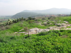
Tel Jezreel. By Ori~ – Own work, Attribution, https://commons.wikimedia.org/w/index.php?curid=8826393
Yoqne’am Regional Project looks beyond the tell.
In the center of Israel there is a wide, fertile, well-watered plain called Jezreel (pronounced Jezre-el). Today it is the agricultural heartland of Israel—an area of open wheat, cotton and corn fields, fish ponds and agricultural settlements. In the past it was the battlefield where Barak, the commander of the prophetess Deborah, routed the chariots of Jabin, King of Hazor (Judges 4), where Gideon marched from his camp at Ein Harod and surprised and defeated the Midianites (Judges 7), where Saul and his son Jonathan were slain by the Philistines on the slope of Mt. Gilboa (1 Samuel 31), and where Pharaoh Necho massed his army at Megiddo against the forces of King Josiah of Judah (2 Kings 23-29ff). The plain of Jezreel continued to be a stage for important events through the Crusader and Moslem periods up to Israel’s War of Independence.
Jezreel is bordered by the hills of the Galilee on the north, the Samarian hills on the south, and the mass of Mount Carmel to the west. To the east the plain drops off sharply into the deep gorge of the Jordan river. Today the western portion of this historic area is the focus of a regional archaeological study, a relatively new approach to archaeological investigation which is replacing the study of isolated tells.
Read the rest of The Regional Study—A New Approach to Archaeological Investigation in the online Biblical Archaeology Society Library.