
 Bible and Beyond
Click here to view the original article.
In the shadow of Mt. Gilboa in the northern Jordan Valley stands one of Israel’s largest, most important archaeological sites—and, until recently, one of the least known. Yet there is nothing hidden or obscure about the site. Indeed, Tel Rehov is hard to miss. The mound stands out prominently just 1,500 feet east of Israel’s Highway 90, the main route between Jerusalem and the Sea of Galilee. Rising above the fields of a local kibbutz, Rehov is seen each year by tens of thousands of passing motorists. But it is rarely visited, even by archaeologists.
The reason for this benign neglect is simple- The site is not mentioned in the Bible. Several other places named Rehov do appear in the Bible, but they are not in the northern Jordan Valley. For example, two places named Rehov are mentioned in the territory allotted to the tribe of Asher (Joshua 19-28, 30), but our Tel Rehov is far east of the coastal territory of Asher. Similarly with an Aramean town and state in Syria, mentioned mainly in relation to David’s conquests (2 Samuel 10-6, 8). So, for the better part of a century, when early Biblical archaeologists were digging more famous sites, Rehov was ignored. It simply slumbered like a perfect time capsule, enigmatic and untouched—except when used as a camp site, a lovers’ lane or, in more recent years, a launching pad for hang gliders.
All that changed, however, in 1997, when our excavations at Rehov began.1
Although Tel Rehov does not seem to have been mentioned in the Bible, it does figure in ancient Egyptian sources. Again, geography provides the key to whether our Rehov or another is referred to. Sometimes it is difficult to tell, but a number of references are unquestionable.2 For example, in Pharaoh Shishak’s list of cities he conquered on his campaign through Israel in about 925 B.C.E., Rehov is mentioned between “The Valley” and “Beth-Shean.”a We will return to Shishak’s invasion and to Beth-Shean. Here it is enough to note that our Rehov is just a little more than 3 miles south of Beth-Shean.
Long before Pharaoh Shishak’s invasion, another Egyptian monarch campaigned in this area. In about 1400 B.C.E., Pharaoh Seti I sought to put down an alliance of rulers who were trying to shake off Egyptian hegemony. Seti left a stele at Beth-Shean commemorating his victory. In the inscription, Seti noted that Beth-Shean was seized by a “wretched foe,” who “does not permit the prince of Rehob to go outside.”3
Apparently, Rehov, the main Canaanite city in the Beth-Shean Valley and neighbor to the Egyptian military stronghold at Beth-Shean, remained loyal to the pharaoh.
In a 13th-century B.C.E. papyrus known as Papyrus Anastasi I, an Egyptian scribe asks his colleague to “let me know Rehob, explain Beth-Shean and Tirqa-El. The stream of Jordan, how it is crossed? Let me know the way to pass Megiddo, which is above it.”4
These are all clear references to our Tel Rehov. The reason there are so many other Rehovs is probably because the name is so simple, meaning “street”—an important component of any city. Our Rehov sits on an important international crossroads—where the north-south highway from Jerusalem and Jericho in the south up the Jordan Valley to Syria in the north intersects with the east-west trail that runs through the Jezreel Valley across the Jordan River into Gilead.
From the Egyptian inscriptions, we can conclude that in the 14th to 13th century B.C.E. (the Late Bronze Age), Rehov was an independent city-state, with its own ruler. It probably ruled the entire Beth-Shean Valley at this time, although the Egyptian garrison for the area was at nearby Beth-Shean. By the tenth century B.C.E., at the time of Shishak’s invasion, Rehov was an important Israelite city. The name has survived in a Jewish town from the Byzantine period—named Rehov—and in the name of an Islamic holy tomb at the foot of the mound—esh-Sheikh er-Rihab.
The area around Rehov was heavily settled in ancient times. There are nearly 50 tells within a radius of about 10 miles. Rehov’s prominence is indicated by the fact that it is one of the largest ancient sites in Israel, about the same size as Megiddo. It lies in a rich alluvial plain and is watered by several nearby springs, one on the northern edge of the tell. As already noted, Beth-Shean lies about 3 miles to the north. Four miles to the east is the Jordan River. And the Gilboa Ridge looms about 2 miles to the west.
In 1996 author Amihai Mazar concluded nine seasons of digging at Tel Beth-Shean, from whose walls, according to the Bible (1 Samuel 31-12), the Philistines hung the bodies of King Saul and his sons after they died in battle on the nearby Gilboa Ridge. Ancient Beth-Shean never developed into a major urban center, however.b Surveys in the region clearly indicate that the main Canaanite and Israelite town in the Beth-Shean Valley was located at Tel Rehov. So it was natural in 1997 for the Beth-Shean Valley Archaeological Project to launch a long-term excavation at Rehov.
Tel Rehov resembles a surfacing whale. The head—an elevated upper city—rises 65 feet above the plain. The tail, or lower city, trails away to the north, 25 feet above the plain. The total tell is 25 acres, divided about equally between the upper and lower cities.
Archaeologically, Tel Rehov is a particularly attractive site- It is large enough that we can “peel back” substantial horizontal areas, revealing broad uninterrupted occupational layers. On the other hand, because it is so large, regardless of how long we dig, even if we go on for decades, we will be able to expose only a small fraction of the tell. Of course, that means that our work can always be checked by later excavations, which may have more powerful techniques than we do.
We have now completed three seasons at Tel Rehov, enough to report our preliminary results to BAR readers. Not only have the finds been illuminating, but Tel Rehov has emerged as a key site for the study of a crucial 500-year period in the history of Israel—from about 1200 to 700 B.C.E. (Iron Age I and the first part of Iron Age II). The last occupation phases from this period are particularly well preserved and easily accessible—making the site ideal for studying the tenth and ninth centuries B.C.E., the time of the United Monarchy of King David and King Solomon and of the Dynasty of Omri in the northern kingdom of Israel. This period is currently the focus of a heated debatec over the dates of various archaeological phenomena and their significance in writing the history of this period in ancient Israel. Our excavations have produced rich data relating to this debate.
In six different excavation areas (labeled A through F), we have tentatively identified 11 different strata (occupation layers), often with subphases, dating from as early as the 16th century B.C.E. to as late as the Islamic period (12th century C.E.). In this article, however, we are going to focus on a narrower time band—from the end of the Late Bronze Age (about 1300–1200 B.C.E.) through Iron Age I (1200–1000 B.C.E.) into Iron Age II, up to the Assyrian destruction of 732 B.C.E., after which the site was largely abandoned.
During the 550 years that will be our focus, the site was destroyed as many as five times. Despite the rather large number of destructions and rebuildings, however, Rehov retained its urban character and continued to thrive until the final Assyrian destruction.
Mudbrick architecture predominates at Rehov. Stones were rarely used. When they were, it was usually to provide some foundation for a wall. Mudbrick requires a very specific method of excavation- Brooms and pointed trowels are the most important tools—not picks. Our staff and volunteers—students and lay people from all over the world, and of a variety of ages and backgrounds—are carefully trained in this difficult digging process, which differs greatly from that at sites where stones were the primary building material.
Another unusual feature of our site is the preservation of carefully stratified organic materials—grain and wood—that can be subjected to carbon 14 testing to determine the date. This is of some importance in the debate over the pottery chronology of the tenth century B.C.E.
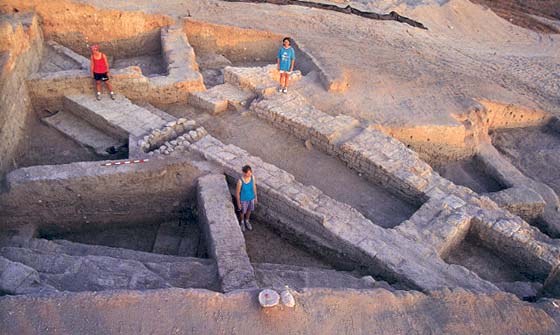
In both the upper and lower city, we dug a deep trench on the edge of the mound (Area B in the upper city; Area D in the lower city, shown in the photo below), designed to expose the internal structure of the tell and its defensive features. In addition, we dug in three other areas in the lower city and one in the upper city.
From the period of Canaanite hegemony (13th through 11th century B.C.E.), we found a continuous development of Canaanite culture, in which different assemblages of pottery can be identified with different strata. We distinguished three Canaanite cities (one per century), each with a major building period followed by a destruction, followed by a less extensive rebuilding. The pottery was typical Canaanite pottery, mostly rough, occasionally painted. This distinguishes it from the hallmark of later Iron Age II pottery (beginning in the tenth century B.C.E.), which is often burnished (rubbed smooth) and red-slipped (dipped in or smeared with reddish paint—see photo, below). In the three major Canaanite levels, we found no red-slipped burnished pottery.
In the second of the three Canaanite cities, we uncovered two so-called foundation deposits, a kind of buried good luck charm intended to bring a blessing on the house. Each foundation deposit consisted of an oil lamp between two pottery bowls. Such foundation deposits are a well-known feature of the transitional Late Bronze Age–Iron Age I period and have also been discovered at Beth-Shean.
In the latest of the three Canaanite cities (11th century B.C.E.), we discovered 33 pits. Some of them were unplastered, while others were sealed with a white lime plaster. The former were perhaps used for refuse; the latter, for grain storage. Indeed, in some of these we found small quantities of grain and olive pits.
Although we found lots of mudbrick walls of buildings in the Canaanite cities, there was no evidence of a city wall. All three Canaanite cities were apparently unfortified.
The next strata, above the Canaanite cities, all belong to Iron Age II, beginning in the tenth century with what is apparently the first Israelite city. The earliest of these Iron Age II cities was revealed in the lower city. Parts of a large building were exposed; its main feature is a large hall with mudbrick walls preserved to a height of 18 courses, with two openings still preserved to their full height—an unusually high degree of preservation. This city was destroyed and immediately rebuilt in a somewhat different layout. What caused the destruction is not clear. If it was the result of warfare, it could have been destroyed by Pharaoh Shishak in 925 B.C.E., after the death of King Solomon. It could also have been destroyed by an earthquake. The pottery found in this city differs considerably from that in the earlier Canaanite strata. The painted decoration and many of the pottery forms of the Canaanite tradition disappear, and new forms now appear. Many vessels are covered with highly burnished red slip.
This new tradition continues with almost no change in the following level, which we uncovered just below the topsoil of the lower city. We dug parts of several large buildings. One of these buildings contained two basement chambers, apparently entered by ladder. In one of the chambers, we found a large quantity of charred wheat, which can be subjected to carbon 14 tests.
Other parts of this building had an unusual architectural feature- Wooden logs and beams were used as a foundation for the walls and floors. Sometimes the wood was superimposed on, and sometimes it was interspersed with layers of mudbrick. The wood was carbonized by a fire that destroyed the building, but it can nevertheless be carbon 14 tested. This type of wooden foundation for mudbrick walls and clay and plaster floors is unparalleled elsewhere in the Levant. It may have been intended to protect the building against earthquakes, a special hazard in the Jordan Valley.
Another unique discovery from this era in the lower city- an Israelite “high place,” or bamah (plural bamot). High places are frequently mentioned in the Bible. The open-air sanctuary at Rehov seems to have served a small community or perhaps an extended family or clan. The sanctuary consists of a nearly square mudbrick platform about 10 feet on a side, with a smaller stone platform, about 3 feet square, on top of it. On one side of this smaller platform were four larger stones. Two of them were elongated and were set up on their shorter, narrower side. These can be interpreted as “standing stones” (Biblical massebot).
In front of the mudbrick platform was a large flat limestone slab (2 × 1.5 feet) supported by five smaller stones, possibly an offering table.
Next to the mudbrick platform were the broken pieces of a large, square, hollow pottery cult stand with a flat top (see photo). The stand’s facade has two rows of triangular windows, standing alternately on their base and apex. Above the windows is a decoration made of reed impressions. Two tenth-century cult stands of similar design were found across the Jordan at Pella.5 Functionally, our cult stand recalls stone altars known from Megiddo and elsewhere. The flat top may have been used for incinerating offerings, such as pigeons. Cult stands found at Megiddo had clay horns projecting from the top four corners, and the likelihood is that our altar also originally had horns, since in another area of the site we found a fragment of an altar that indeed still had a horn at one corner.
Pottery near the mudbrick podium included a number of chalices—additional evidence of cultic activity in this open area. Still more evidence included a lavishly painted storage jar in Phoenician style (see photo), a head of a bull figurine made of bronze, two clay female figurines, a clay animal figurine and a few seals.
The entire installation was on the edge of a spacious courtyard, where a number of ovens and other installations were most probably used for preparing sacred meals. A large quantity of animal bones was found in front of and to one side of the mudbrick podium. Many of the bones were of wild goats (as identified by our osteologist, Mary Craig), while elsewhere at the site the bones consisted mainly of sheep, cattle and domesticated goats. Was the wild goat a special kind of sacrifice?
In any event, this Israelite cult installation is unparalleled- While other small Israelite cult places are known—for example, at Megiddo, Lachish and Taanach—ours is unique in its plan and its inclusion of standing stones and a podium. The standing stones are reminiscent of contemporaneous massebot found in abundance near the city gate at Dan.d
The only inscription from this period consists of several letters incised on a pottery sherd. This inscription can be dated to the tenth century B.C.E. on the basis of both its context and the letter forms. The first letter is the very common Hebrew letter lamed, or L, meaning literally “belonging to.” This is followed by a personal name that begins with nun, or N, but the rest of the letters are not clear. This is one of the very few Hebrew inscriptions from the tenth century B.C.E. found in the Land of Israel.
These findings—the high place, the standing stones, the inscription—are all from the lower city.
In 1999, while working in the upper city, we found massive buildings with the same timber construction and pottery that we had found in the lower city. This allowed us to connect the stratigraphy in the upper city with that of the lower city.
Heavy fire, most probably the result of conquest by war, destroyed this city. In both the upper and lower city, the rooms of the buildings were found full of broken yet restorable pottery vessels, accompanied by seals, clay figurines and metal objects. Who caused this heavy destruction? The pottery, including imported Cypriot and Phoenician pottery, indicates that it probably occurred sometime during the ninth century B.C.E., possibly in one of the turmoils following the death of the Israelite king Ahab (ruled c. 872–851 B.C.E.), such as the revolt of Jehu (ruled c. 841–818 B.C.E.) or, more plausibly, during the invasion of Israel by Hazael, king of Aram-Damascus, in about 835 to 830 B.C.E.
This conquest and destruction must have been traumatic. After centuries of continuous settlement, the lower city was abandoned, and the settlement at Tel Rehov shrunk to half its earlier size. Only the upper city was now inhabited. Our excavation in the upper city revealed two occupation strata belonging to the period between the late-ninth-century B.C.E. destruction and the final destruction of the Israelite city by the Assyrian army of Tiglath-pileser III in 732 B.C.E. During this period, the inhabitants of Rehov apparently felt the city needed the protection of a wall. The double wall built around the upper city was made of mudbricks. The outer wall was 4 feet thick and the inner wall 2.5 feet. A massive mudbrick structure that appears to be a tower abuts this double-wall system. A stone drain inside the double wall drained rainwater from inside the now-fortified city.
Later in the eighth century B.C.E., as the Assyrian superpower became a real threat, this double-wall system was no longer considered sufficient. It was replaced by a massive 30-foot-thick city wall. Part of this mudbrick city wall has survived in places to a height of over 5 feet—14 courses. We speculate that it may originally have stood as high as it was thick. In any event, its construction was an enormous undertaking. In plan, the wall is of the “offset-inset” type—with regularly spaced 6-foot-deep insets alternating with similar offsets. The wall has no foundation, not even one made of stone, and its mudbricks are of poor quality. It thus appears to have been hastily constructed, when the Assyrian danger was imminent.
The great thickness of the wall was probably intended to withstand the threat of Assyrian battering rams, which destroyed almost every city wall in the ancient Near East. Alas, despite all efforts, the walls of Rehov also fell to the sophisticated Assyrian warfare machine headed by Tiglath-pileser III. The city he destroyed is badly burned and covered with destruction debris.
Poignant evidence of the ferocity of Tiglath-pileser’s attack was found in a heavily burned dwelling. In two of the rooms, we uncovered human skeletons, apparently Israelites who were massacred by the Assyrians. One skeleton was found in a contracted position with the skull missing; the man or woman (we cannot identify the gender) fell upon a heap of clay loom weights. The second skeleton, that of a young woman, was apparently thrown into the corner of the room; she died in a semi-upright position, her hands holding the knees of her bent legs. Her death may well have been the result of a massacre of people in their homes. In any event, these skeletons testify to the violent and dramatic end of Israelite Rehov.
Apparently the Assyrians occupied the site for a short while after they destroyed it. In addition to a few post-destruction floor surfaces, we discovered two Assyrian burials, each of a single man in a contracted position with an intact Assyrian pottery bottle next to him. One burial also included a fragment of an iron knife or sword. These may be the remains of Assyrian soldiers or officials.
So what are the implications of these findings for the current debate over the tenth century B.C.E.?
During the last decade, several scholars have raised questions about the validity of the Biblical narrative relating to the United Monarchy of David and Solomon, and about the archaeological background for this period. The views of Israel Finkelstein, an archaeologist at Tel Aviv University and co-excavator of Megiddo, are of special interest because he has suggested lowering the date of pottery assemblages from this period by about 80 years- The assemblages usually dated to the time of King Solomon (mid-tenth century B.C.E.) Finkelstein dates to the time of King Ahab (mid-ninth century B.C.E.); similarly, pottery assemblages traditionally dated to the 11th century B.C.E. he down-dates to the tenth century B.C.E. His suggestion has resulted in a debate between us in the journal Levant.6 This debate has important implications for our understanding of the United Monarchy, since if we accept Finkelstein’s dating, the archaeological picture relating to the United Monarchy is very different from what is commonly accepted by scholars.e
The excavation at Tel Rehov provides new data that enable us to evaluate the chronology of the tenth and ninth centuries B.C.E. In our view, only a part of Finkelstein’s ideas can be accepted, while his main argument is unacceptable. An examination of the pottery from Rehov and several other sites will help us explain the issue.
In the period we are focusing on—13th to 8th century B.C.E.—two major groups of pottery must be considered separately. The first is the Canaanite pottery from the 13th through the 11th century B.C.E. The second group comes from the 10th to the 8th century B.C.E.
The first major grouping can be subdivided into three phases. In the 13th century, we find standard Late Bronze Age II pottery traditions—the pottery is unburnished, unslipped and sometimes painted. These traditions continue into the next phase, although a few new forms are introduced at this time. These same new forms appear at contemporaneous Beth-Shean, where they can be correlated with an unquestioned Egyptian 20th Dynasty context (12th century B.C.E.). Their date is therefore secure. In the third phase, the late 12th and 11th centuries B.C.E., we still find at Rehov the same basic Canaanite traditions, again with the introduction of a few new forms. In addition, a unique kind of red-painted pottery appears, decorated with some wavy and some horizontal lines, but—and this is significant—no slip or burnish. The important point to notice is that the basic Canaanite pottery traditions persist during this entire period.
Then there is a dramatic change, a change that in our view marks—both at Tel Rehov and elsewhere in the northern plains of Israel—the end of the Canaanite traditions in these areas, as they came under Israelite hegemony.
The old tradition of painted pottery now gives way to a new industry, characterized by red slip and hand burnish on bowls, kraters, jugs and juglets. Painting is limited to a few geometric designs, often on red slip. In the lower city of Tel Rehov, this new pottery tradition appears with almost no change in the city destroyed in the late tenth century B.C.E. and in the following city, destroyed in the late ninth century B.C.E. Similar pottery was found in all the strata of other sites in the north that are traditionally dated to the tenth century B.C.E., such as Megiddo, Hazor and Taanach.
However, similar pottery has also been found in a destruction level at Jezreel that must be dated to after the death of King Ahab in the mid-ninth century B.C.E., between 840 and 830 B.C.E. This has led Finkelstein to suggest that all sites with similar pottery should be dated to the ninth century B.C.E. Yet, in our view, he errs in attributing this pottery always and only to the ninth century. The evidence at Rehov demonstrates that this assemblage had a long life and that it was already well known in the tenth century B.C.E. In each of the two strata (or cities) that existed in the lower city from the tenth to the ninth century we found subphases with successive floor surfaces and architectural changes, so this pottery assemblage must have lasted a long time. There are simply too many strata with subphases to squeeze the stratigraphic sequence at Rehov into half of the ninth century B.C.E.
In historical terms, this means that it is almost impossible to distinguish the pottery from the period of the United Monarchy (tenth century B.C.E.) from the pottery of the ninth century B.C.E. (the time of Omri and Ahab). Only a meticulous quantitative study of the rich assemblages from Tel Rehov will allow us to determine whether in the future we will be able to distinguish between the pottery assemblages of these two centuries. When we complete this study, it will have important implications for our understanding of other sites in this period, such as Megiddo, where the evidence is still insufficient. Even at this point, however, it is clear that Israelite material culture developed slowly and gradually at this time.
Following the late-ninth-century B.C.E. destruction of the city (after which the lower city was abandoned), there was a change in the pottery- The last two strata of the Israelite city—excavated in the upper city—contained new forms of pottery that are well known in other northern Israelite towns in the ninth and eighth centuries B.C.E.
Several carbon 14 tests support our reasoning, although they are not entirely unambiguous. Carbon 14 tests were performed on samples of charred grain and a beam of an elm tree, both from the latest stratum (Stratum 1) of the lower city.7 Fourteen samples of grain were dated by two separate laboratories to somewhere between 906 and 843 B.C.E. (with a 66 percent probability of falling within this range) or between 916 and 832 B.C.E. (with a 98 percent probability of falling within this range). However, the elm tree dated to 1120–990 B.C.E. The wood may well have predated its use as lumber in the construction of the building, yet it does hint at the construction of the building sometime in the tenth century B.C.E.
Rehov is now revealed as one of the largest and most important sites in the country from the 13th century B.C.E. (the Late Bronze Age) to the mid-eighth century B.C.E. (Iron Age II). From all the evidence, it seems clear that during the tenth century B.C.E., the time of the United Monarchy, Rehov was a well-planned, thriving city of about 25 acres, with a material culture that resembles other sites throughout the country that are dated to the tenth century B.C.E., according to the traditional chronology. Sometime in the late tenth century, the city was destroyed, either by an enemy (Pharaoh Shishak?) or by nature (earthquake?). Yet it was soon rebuilt on a similar plan, only to be destroyed by violent fire, probably after King Ahab’s reign in the mid-ninth century B.C.E. Following this destruction, the lower city was abandoned. Life continued, however, in the upper city until it, too, was violently destroyed in 732 B.C.E. by the Assyrian monarch Tiglath-pileser III.
After only three years of digging, Rehov has revealed significant data relating to one of the most enigmatic questions in Biblical history—the nature of the rise of the Israelite state in the tenth and ninth centuries B.C.E.8 The long-neglected site promises to play a key role in the future, as we try to understand the history of ancient Israel.
Join a Dig
The Rehov excavation is seeking volunteers for its 2000 dig season. Information is available on the Web at <www.rehov.org> or in our own annual list of digs, available in the January/February 2000 issue of BAR or on the Web at <www.bib-arch.org>.
a. Shishak is his name in the Bible (2 Chronicles 12-2). In Egyptian sources he is called Sheshonq.
b. Over time, this would change. At the foot of the ancient tell lie the fabulous remains of the largest and best-preserved Roman-Byzantine city in Israel. See “Glorious Beth-Shean,” BAR 16-04.
c. See the following BAR articles by Hershel Shanks- “Where Is the Tenth Century?” BAR 24-02, and “Mickey Mouse Operation,” BAR 25-02.
e. For a traditional view of the situation at Hazor, for example, see Amnon Ben-Tor, “Excavating Hazor—Part I- Solomon’s City Rises from the Ashes,” BAR 25-02.
1. The excavations at Tel Rehov are carried out on behalf of the Institute of Archaeology of the Hebrew University in Jerusalem. The excavations are directed by Amihai Mazar and sponsored by John Camp, who is also the field photographer of the expedition. The core staff includes Adi Asudri; SeJin Koh; Robert Mullins; Nava Panitz-Cohen; Amir Sumakai-Pink and Dalit Weinblatt. Maria Caplan is the surveyor.
2. Shmuel Ahituv (Canaanite Toponyms in Ancient Egyptian Documents [Jerusalem- Magness Press and Brill, 1984], pp. 163–165) classifies the Egyptian sources as referring to three cities of that name- one in the Akko Valley, a second in the northern part of Western Galilee, and the third in the Beth-Shean Valley.
3. “A Campaign of Seti I in Northern Palestine,” in Ancient Near Eastern Texts Relating to the Old Testament (ANET), 3rd ed., ed. James B. Pritchard (Princeton, NJ- Princeton Univ. Press, 1969), p. 253.
4. Papyrus Anastasi 1, in Pritchard, ANET, p. 477.
5. A.W. McNicoll et al. in Pella in Jordan 2, Mediterranean Archaeology Supplement 2 (Sydney, Australia- Meditarch, 1992), pp. 97–100, pls. 70–71.
6. Israel Finkelstein, “The Archaeology of the United Monarchy- An Alternative View,” Levant 28 (1996), pp. 177–187; Amihai Mazar, “Iron Age Chronology- A Reply to I. Finkelstein,” Levant 29 (1997), pp. 157–167. For Finkelstein’s reply to this response, see Finkelstein, “Bible Archaeology or Archaeology of Palestine in the Iron Age? A Rejoinder,” Levant 30 (1998), pp. 167–173. In this rejoinder, Finkelstein preaches against anchoring archaeological phenomena in Biblical data, yet he does exactly that by using the destruction of Jezreel as a datum point for his Achronology!
7. A test was made on an olive tree, but it apparently was from a very old tree since it dated to a much earlier period (1400–1260 B.C.E.). For this reason, we ignore it here. An elm tree has a much shorter life. The carbon 14 dates were made in the laboratories of the University of Arizona and the Weizmann Institute, Israel.
8. For further reading, see A. Mazar, “The 1997–1998 Excavations at Tel Rehov- Preliminary Report,” Israel Exploration Journal 49 (1999), pp. 1–42. The article is available on the Web at <www.rehov.org>.