
 Solomon’s City Rises from the Ashes
The fiery destruction of Hazor, the Book of Joshua recounts, was the final episode in the Israelite conquest of Canaan. Once Joshua burned down this key city—“the head of all those kingdoms,” as Joshua 11-10 puts it—the land of Canaan was open to Israelite settlement.
Over the centuries, a new city rose from the ashes. According to the Bible, during the days of the United Monarchy, King Solomon fortified the city (1 Kings 9-15).
The rebuilding of Hazor by the Israelites during the Iron Age (c. 1200–732 B.C.E.) will be discussed in the first installment of this two-part article. The second installment will explore the life and death of the earlier, Canaanite city—and will look into the puzzle of who destroyed it.
Hazor was the most important site in southern Canaan. It controlled the main trade and military routes that connected Israel to Phoenicia and beyond, to Syria, Anatolia, Mesopotamia and Egypt.
Hazor also holds an honored place in the history of modern Israeli archaeology. The expedition to Hazor in the mid-1950s, led by the late Yigael Yadin, was the largest and most important archaeological excavation undertaken by the young state of Israel. Between 1955 and 1958, during four three-month excavation seasons, Yadin employed hundreds of workers spread over the 200-acre site. He opened four excavation areas on the tell itself and six in the so-called lower city. Ten years later, in 1968, Yadin returned to the site for his final season, during which four additional areas were explored, two on the tell and two in the lower city. Most of today’s senior Israeli archaeologists worked with Yadin, or rather under him, at Hazor. Here, more than at any other site in the country, the next generation of Israeli archaeologists was trained.
Yadin was drawn to Hazor largely by his interest in the Bible. Like much of archaeology west of the Jordan in the period both before and immediately after the Second World War, the excavation of Hazor was motivated by a desire to confront the Biblical narrative, especially the accounts of the Israelite “conquest” of the Promised Land and settlement of Canaan. How would data from excavations at sites mentioned in the Bible enlighten the Biblical narrative? This interest explains why excavations were undertaken at sites like Jericho, Ai, Bethel, Shiloh—and, by Yadin, at Hazor. (Indeed, soundings at Hazor had already been undertaken by the British archaeologist John Garstang in 1928.)
According to the Bible, in an attempt to stop Joshua, King Jabin of Hazor led the forces of five Canaanite city-states, which assembled at the Waters of Merom to battle Joshua. Hazor, the Book of Joshua recounts, was “the head of all those kingdoms” (Joshua 11-10). The Canaanite forces are described as “an enormous host, as numerous as the sands on the seashore—and a vast multitude of horses and chariots” (Joshua 11-4). With the Lord’s help, however, Joshua defeated this multitude and then turned back and captured Hazor, which he burned. Of all the cities subdued in the Israelite conquest of the Promised Land, Hazor alone was torched (Joshua 11-11).
Yadin wanted to uncover not only Israelite Hazor, but Canaanite Hazor as well. He especially hoped to find a cuneiform archive from the Canaanite period. Although cuneiform archives from the second millennium B.C.E. have been found at sites in Mesopotamia, Syria and even Egypt, none has ever been discovered in Israel. Yadin had good reason to believe that such an archive lay buried in Canaanite Hazor- Letters from Hazor, and letters mentioning Hazor, had been found in some of these other archives.
Yadin never found the archive, but he did find the destroyed Canaanite city of Hazor. Based on the pottery, he dated the destruction of the Canaanite city to the last quarter of the 13th century, approximately 1230 B.C.E., and confidently suggested that the city was destroyed by Joshua as described in the Bible. Both the date of the destruction and the identity of the destroyers have been hotly debated ever since the publication of Yadin’s conclusions (and even earlier, among the excavation staff; a disagreement between Yadin and his arch-rival, Yohanan Aharoni, who served as one of the dig’s area supervisors, prevented final publication of the excavation report until after the deaths of both Aharoni and Yadin).
Yadin was planning to return to Hazor, still confident that he would find the archive, when he died in 1984.
In 1990, 35 years after Yadin began his excavations, a renewed excavation at Hazor, named in memory of Yigael Yadin, began under my direction.1 We had two main objectives- First, we wanted to check the stratigraphy on which Yadin based his chronological and historical conclusions. After so many years of advances in archaeological knowledge and methodology, we felt we were well equipped to test Yadin’s conclusions.
Second, we wanted to explore several important issues left unresolved by the Yadin expedition, such as the date of the destruction of the Canaanite city. Further, during the 1958 season, Yadin uncovered the corner of a Canaanite palace, but that’s all. We wanted to look at it more extensively. And although Yadin failed to find an archive, he did find evidence that seemed to confirm it was there- a small bilingual cuneiform text. (And in 1962, after the excavation had closed, an American tourist found on the surface of the mound a fragment of a cuneiform tablet that mentions Hazor and refers to its ruler as king.a
To break the suspense at the outset- We have just completed our ninth season and we have still not located the cuneiform archive (or archives—there may be more than one, we now have reason to believe). We still have a few more seasons to go, and we seem to be getting close, as indicated by a handful of stray cuneiform tablets already uncovered. These will be discussed in the second installment of this article, as will the Canaanite palace.
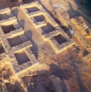
Whereas Yadin opened ten areas, we confined ourselves to two. Both are on the acropolis, or tell (which is shaped like a soft drink bottle), rather than in the lower city. One, Area A (in both Yadin’s designation and ours), lies in the center of the tell. By expanding Area A, we hoped to tie our stratigraphy to that established by Yadin. Moreover, the corner of the Canaanite palace that Yadin found in the 1950s is in this area. So is a famous six-chambered Israelite gate.
Readers may immediately wonder what a city gate is doing in the center of the tell. Gates are usually on the periphery of the city, as are the city walls to which they are attached. The explanation is that the earliest Israelite city wall at Hazor enclosed only the western half of the tell, so the six-chambered gate actually was on the periphery of the city, although not on the periphery of the mound. Later, as we shall see, the city expanded to include the eastern half of the mound, at which time the wall was extended to enclose that area as well.
Which leads to the choice of our second area of excavation—where the new wall connects to the old wall on the northern side of the tell. This is Area M, which Yadin exposed only in the 1968 season. Here, at the meeting point of the tenth- and ninth-century fortification systems, we wanted to study the history and development of the fortifications of the site. We could also study here the area that connected the upper city with the lower city, as well as an intriguing small plateau in the central part of the northern slope.
Following the destruction of Canaanite Hazor, the lower city was abandoned forever. What had been a 200-acre urban site was, when resettled, reduced to about 10 acres on the western half of the tell.
The earliest occupational remains following the destruction of Canaanite Hazor are extremely meager. The most ubiquitous feature of this settlement are pits, in no specific order, all over the site. The pits are generally circular, about 3 to 5 feet in diameter and the same amount in depth. Some other pits found at the site are about double this size. The pits are usually found filled with ashes, broken bowls, storage jars, cooking pots and an occasional grinding stone. The function of these pits is unclear, but they have been found at numerous other sites as well. Archaeologists often refer to them as Israelite Settlement Pits because they generally date to Iron Age I (12th to 11th century B.C.E.), the time of the Israelite settlement in Canaan, sometimes called the period of the Judges; the pits were at one time thought to be settlement hovels. Yadin found (in his Area B) a cult structure, or “high place,” from this period that contained a bench-like installation. On the floor were a jugful of bronze votive objects and two broken incense stands. With the exception of this high place, however, we found almost no architecture, not even fragmentary walls, that can be attributed to Iron Age I.
The stratigraphy of these pits is clear- They were cut into the destruction layer of Canaanite Hazor. And they were, in turn, built over during the first substantial architectural phase of Iron Age Hazor (Iron Age II). Their date, their use and the identity of the people who dug them are less clear. Yadin attributed them to the Israelites settling down in the 12th to 11th century B.C.E. There are, however, problems with this identification.
In Area A, we found only one stratum (occupation layer) dating to Iron I, as did Yadin. In Area B (where we did not dig), he found two Iron I strata. Either case presents a problem. Iron I is generally dated from about 1200 to 1000 B.C.E., a 200-year period. This is far too long for a single stratum, even for two strata. On the basis of our discoveries, we estimate that Iron Age I at Hazor lasted for 50 to 100 years at most. This leaves a gap of at least a hundred years in the occupation of Hazor in the Iron I period. But we are still unsure whether this break occurred at the beginning or the end of Iron Age I; in other words, we are not sure whether to date the Iron Age I pits to the 12th or the 11th century B.C.E. When we determine this, we will know whether there was a gap in occupation immediately after the destruction of Canaanite Hazor or just prior to the resettlement of the city in the tenth century (the beginning of Iron Age II).
In Iron Age II (1000–732 B.C.E.), Hazor flourished once again. The tenth century B.C.E. is perhaps the most hotly debated period in the history of the country, as BAR readers well know.b It is of special importance in Biblical history; it was then that King David and King Solomon ruled under the United Monarchy, the era of Israel’s greatest glory. But how much of the Biblical account is historical and how much scriptural exaggeration?
First Kings 9-15 states that Solomon imposed a corvée (a system of conscript labor) that helped fortify “Hazor, Megiddo and Gezer.” One of Yadin’s prize discoveries was a six-chambered city gate connected to a double (or casemate) wall. This wall runs in a north-south line, cutting the upper city in two, an eastern half and a western half. It then encloses the western half of the tell, all that was occupied at this time. Yadin dated this wall and gate to the tenth century B.C.E. Nearly identical six-chambered gates were also uncovered at Megiddo and Gezer. Yadin attributed all three fortification systems to King Solomon. Thus was born “the archaeology of the United Monarchy.”
For many years, Yadin’s dating was widely, although not universally, accepted. More recently, however, it has come under heavy attack. Some scholars, for a variety of reasons, would lower this dating to the ninth century B.C.E. (both at Hazor and at other sites, especially at Megiddo, whose current excavators are among the most prominent opponents of Yadin’s dating). This disagreement over dating is all the more caustic because it occurs in the context of the debate over the basic historicity of the United Monarchy- Some scholars now argue that the accomplishments of David and Solomon are not simply exaggerated in the Bible (to this most scholars would agree), but that these kings either were fictitious characters or were nothing more than minor local “chiefs.” In the view of these scholars, neither David nor Solomon would have been capable of executing such large-scale building activities as those commonly attributed to them at Hazor, Megiddo and Gezer.
One of the main aims of our re-excavation was to clarify the date of the stratum Yadin attributed to the tenth-century B.C.E. United Monarchy.
The first thing we wanted to do was to excavate more of this stratum to the west of the six-chambered gate and the casemate wall. We focused on what appeared to be a large tenth-century B.C.E. building, of which Yadin had uncovered only a small part. He did not excavate the building any further because two other, quite imposing buildings, which he dated to the ninth to eighth century B.C.E., had been built over it. One was a tripartite pillared building, to be discussed below, and the other was a so-called four-room house, a type commonly associated with Israelite architecture.
To overcome the obstacle of these overlying buildings, we decided to do something that had never been done before in any excavation in Israel- Instead of simply dismantling these buildings to reach the stratum below, we decided to move them! We had had this in mind ever since the planning phase of our expedition. Exposed to the elements since the 1950s, these buildings had deteriorated badly. Walls, doorjambs and ashlar-built corners had collapsed to such an extent that the stability of the two structures was endangered, and visitors were not permitted near them. Partially for this reason, Hazor was attracting only a small number of tourists. Moving and restoring these buildings would make them meaningful and attractive not only to archaeologists but to the general public as well.
We found a suitable location for the buildings about 300 feet northwest of their original location, in an area where Yadin had uncovered the remains of domestic structures commonly found all over Hazor. Before moving them, we carefully numbered all important architectural elements on the plans and on the stones themselves. The two buildings were then moved stone by stone to their new location by expert Druze stonemasons. No cement or other modern building material was used to bind the stones. Once again, the buildings stand on solid foundations, all the different elements having been rebuilt and secured. Even an oil press, which originally functioned in the courtyard of one of the buildings, was fully restored. The buildings are now open to the public and tourists are once again flocking to the site, as they did in the years after Yadin’s excavation. We also restored the six-chambered gate and the Israelite high place from the 11th century B.C.E.
Once these buildings had been moved, we were able to excavate beneath them and expose a large building that Yadin had only partially uncovered. (This building lay above the remains of the Canaanite palace, only one corner of which Yadin had discovered.) We identified four different architectural phases of this building, each accompanied by a rich pottery assemblage. On the basis of a detailed comparative study, we were able to determine when the building was used- from the second half of the tenth century to the beginning of the ninth century B.C.E.
What does this tell us about the date of the six-chambered gate that Yadin attributed to King Solomon and the casemate wall attached to it? City gates and walls are notoriously difficult to date. They continue in use for a long time and, generally, very little pottery (used for dating) is associated with them. Whatever is found usually dates to the latest period of use.
The building with four phases is located just inside the casemate wall and is separated from it by a paved street. The pavement runs up against the outer wall of the building and against the inner face of the casemate wall. The pavement is thus related to the earliest of the four phases during which the building was in use. And the building is related to the casemate wall, which in turn is bonded to the six-chambered gate. The building—and therefore the units to which it is related—is datable by means of a rich pottery assemblage, found on the floor of the building, that was unavailable to Yadin. Our conclusion is that the six-chambered gate, the casemate wall and the earliest phase of the building all date to the second half of the tenth century B.C.E.
Our conclusion is based not only on the pottery, however, but also on the stratigraphy of the site. The destruction of Israelite Hazor is firmly dated to the campaign of the Assyrian monarch Tiglath-pileser III in 732 B.C.E. For Iron Age II, which begins in about 1000 B.C.E. and which ends at Hazor with this destruction in 732 B.C.E., Yadin identified six major strata, further subdivided into nine subphases. Our expedition essentially confirmed this stratigraphy, except that we identified even more subphases—possibly as many as 11 or 12. If we accept our judgment, based on the pottery, that the earliest Iron Age II stratum at Hazor dates to about 950 B.C.E., then Iron Age II at Hazor lasted approximately 220 years (until 732 B.C.E.). This means that the average stratum lasted only about 35 years (and only 15 years per phase). This is an exceedingly short time. Compare this with other sites- During the same time period, there were only three strata, each averaging about 70 years, at nearby Dan, as well as at Megiddo, Gezer and Lachish, to name just a few sites. It is in this context that we must ask whether it is possible to lower the date of the earliest Iron Age II stratum at Hazor to the ninth century B.C.E., as has recently been proposed by some scholars. Stratigraphically, this is almost impossible. To lower the date by 50 or even 70 years, as some have suggested, would reduce the length of each stratum and each phase even more. In short, the stratigraphy at Hazor strongly confirms our dating of the six-chambered gate and the casemate wall to which it is attached to about 950 B.C.E.
But are the gate and casemate wall attributable to King Solomon? Unfortunately, the archaeological evidence does not allow us to date them that precisely. That is all I can say as an archaeologist. And I won’t pretend to be a historian or Bible scholar. King Solomon is generally assumed to have ruled in the mid-tenth century. If so, there is no reason why the gate and the casemate wall could not be attributed to King Solomon; but, as likely as this seems, this is not an archaeological conclusion. From an archaeological viewpoint, it could also be attributed, for example, to Jeroboam I, who led the northern kingdom of Israel after Solomon’s death, although this seems less likely.
Several other buildings in Area A date to this same period, as do several structures in our Area M. Thus, we have been able to add substantially to the minimal evidence (limited to the gate and casemate wall) Yadin uncovered for tenth-century B.C.E. Hazor. Nevertheless, during this period Hazor was a rather unimposing settlement confined to the western part of the acropolis, an area of less than 10 acres. We estimate the population of this city to be between eight hundred and a thousand people.
Sometime in the ninth century B.C.E., a major change occurred. The eastern half of the acropolis was enclosed with a solid 10-foot-wide fortification wall that is preserved in places to a height of over 10 feet. The outer face of this wall is marked by insets and offsets, similar to city walls of that period at other sites in the country.
The earlier casemate wall that enclosed the tenth-century B.C.E. city was confined to the western part of the acropolis, but it did not go out of use in the ninth century. It was simply joined to the new city wall in the two places where the two walls met; that is, in the middle of the northern and southern edges of the tell.
One of these joints was exposed by Yadin in 1968. Our excavations in Area M confirmed Yadin’s conclusions with regard to the occupational history of Hazor in the tenth and ninth centuries B.C.E.
With this new wall enclosing the eastern half of the tell, the size of the city was doubled. In addition, the settlement was more densely settled in the ninth century B.C.E. than in the tenth century, so the population must have more than doubled. Yadin uncovered major finds from the ninth-century city, including the two buildings we moved, that is, the large tripartite building divided into three long halls by means of two rows of pillars and the four-room house; a citadel located on the western edge of the acropolis; and a highly engineered water system.
Our excavations revealed even more of this prosperous city- about 150 feet of the solid city wall and three long halls of a tripartite storehouse in Area A divided by walls rather than pillars, but otherwise similar to the tripartite pillared building that Yadin exposed. We also uncovered remains of a similar storehouse in Area M.
All of this reflects a period of considerable prosperity, indeed, the height of prosperity enjoyed by Israelite Hazor. Yadin attributed this building spree to King Ahab (874–853 B.C.E.), who seems to have had some redeeming qualities that are not emphasized in the Bible’s bleak review of his reign.c
The tripartite building we exposed in Area A is of special significance in connection with the ongoing debate about the function of these buildings. Are they storehouses, stables, markets or something else?d Like some tripartite buildings at other sites, the central aisle of ours was paved with thick white plaster, while the long side rooms were paved with stone slabs. Most significant, however, were two complete large pithoi (storage vessels), plus several circular negatives of other such vessels sunk into the floor. This clearly indicates the function of the building as a storehouse, in contrast to the tripartite building Yadin exposed, which had no finds in it. Several similar buildings excavated in the 1930s at Megiddo have long been interpreted as stables. Indeed, the tripartite pillared building partially excavated by Garstang at Hazor in the late 1920s was also identified as a stable built by King Solomon. Yadin finished the excavation of this building but attributed it to Ahab and identified it as a storehouse. The buildings at Hazor clearly seem to be storehouses. The function of these buildings, obviously of a public nature, may have varied from one site to another. Therefore, I express no opinion regarding the function of similar buildings at such sites as Megiddo, Beersheba and Tel Hadar. Each case must be decided on the basis of the particular archaeological evidence.
By the eighth century B.C.E., political conditions in Israel had deteriorated significantly, mainly as a result of growing pressure from the north. Both the Arameans, Israel’s closer neighbor, and the Assyrians, her more distant foe, embarked on periodic military campaigns into northern Syria and Israel, and both had a lot to do with Hazor’s gradual decline. Some of the buildings constructed in the prosperous ninth century B.C.E. naturally continued in use, but the buildings constructed in the eighth century B.C.E. were flimsier, the walls were thinner, and large units from the previous period were subdivided. Other buildings from the ninth century (like our tripartite building) simply went out of use.
Finally, in 732 B.C.E., the Assyrian king Tiglath-pileser III conquered Hazor and destroyed it. The Biblical reference to Hazor’s destruction is fully confirmed both by Yadin’s excavation and our own- “In the days of King Pekah of Israel, King of Assyria Tiglath-pileser came and captured Iyon, Abel-beth-maacah, Janoah, Kedesh, Hazor—Gilead, Galilee, the entire region of Naphtali, and he deported the people to Assyria” (2 Kings 15-29–30).
The archaeological picture, however, appears to contradict the Bible in one respect- Not all the inhabitants of Hazor were deported. Yadin uncovered a series of fragmentary walls postdating Tiglath-pileser’s destruction and attributed this occupation to Israelite “squatters” who survived the Assyrian onslaught and continued to live at the site for a short while. Our excavations have uncovered a more substantial and widespread occupation following the city’s quite thorough destruction. The new evidence comes especially from Area M, outside the solid city wall, where we found houses and various installations of a private nature strewn all over the northern slope of the site. The pottery assemblage is indistinguishable from the previous (predestruction) stratum, indicating that these houses belonged to the same people who lived in the city before the destruction. The city’s defenses were probably in ruins, but there was no enemy threat anymore, so the people who remained could live outside as well as inside the old city wall.
The Assyrian campaign of 732 B.C.E. marked the beginning of the end for the northern kingdom of Israel, however. A decade later, in 722/721 B.C.E., the Assyrians conquered and destroyed Samaria, the capital of the northern kingdom, thus ending the country’s independence.
Interestingly enough, the period immediately following the Assyrian conquest was a prosperous one in most parts of the north. The Pax Assyriaca apparently had its benefits. At neighboring Tel Dan, for example, the post-Assyrian-conquest city was more prosperous than any other Iron Age stratum at the site. Indeed, it was so prosperous that Dan probably replaced Hazor as the main population center of the region. Hazor, however, never recovered.
a. See “American Tourist Returns ‘Hazor’ Tablet to Israel After 13 Years,” BAR 02-02.
b. See “Face to Face- Biblical Minimalists Meet Their Challengers,” BAR 23-04; and Hershel Shanks, “Where Is the Tenth Century?” BAR 24-02.
c. See Ephraim Stern, “How Bad Was Ahab?” BAR 19-02.
Graham I. Davies, “King Solomon’s Stables- Still at Megiddo?” BAR 20-01; and the forthcoming article by Moshe Kochavi in BAR. See also Ze’ev Herzog, “Administrative Structures in the Iron Age,” in The Architecture of Ancient Israel, ed. Aharon Kempinski and Ronny Reich (Jerusalem- Israel Exploration Society, 1992), pp. 223–228.
1. The Selz Foundation Hazor Excavations in Memory of Yigael Yadin is a joint project of the Hebrew University and Universidad Complutense in Madrid, Spain, sponsored by the Israel Exploration Society. Photos and illustrations credited to Studio Sztulman-Kessel, Jerusalem; Maria Teresa Rubiato, of Universidad Complutense; and staff member Ruhama Bonfil appear by courtesy of the Selz Foundation Hazor Excavations.