Excavate King David’s Palace! Eilat Mazar, BAR 23:01, Jan-Feb 1997.
 A careful examination of the Biblical text combined with sometimes unnoticed results of modern archaeological excavations in Jerusalem enable us, I believe, to locate the site of King David’s palace. Even more exciting, it is in an area that is now available for excavation. If some regard as too speculative the hypothesis I shall put forth in this article, my reply is simply this- Let us put it to the test in the way archaeologists always try to test their theories—by excavation.
The Canaanite/Jebusite city that King David conquered in about 1000 B.C.E. was a mere 9 acres on a ridge south of what we call today the Temple Mount. David renamed the city, which he made his capital, the City of David. And that is still what this ridge is called today, ‘ir David in Hebrew.
We know quite a bit about this city—from excavations, topography and the Biblical text. It was wisely chosen because of its proximity to the only perennial supply of water in all Jerusalem—the Gihon Spring, which lies to the east of the ridge near the floor of the Kidron Valley.
Equally important, this ridge is easily defensible as a result of deep valleys on three sides- the Kidron to the east and the Tyropoeon (or Central) Valley to the west and south.
The city’s weak spot lay to the north, where there was no natural barrier. The ridge rises as it moves northward, first to the Ophel (the area between the City of David and the Temple Mount) and then, still higher, to the Temple Mount.
This vulnerable northern boundary is a critically important datum. It was a strategic weak point that called for massive defenses.
At the time of David’s conquest, Jerusalem was a well-fortified city, with a thick city wall dating back to the 18th century B.C.E.1 However, we don’t know precisely where the northern section of this wall was located. It seems likely that in order to make the construction of the defenses as easy as possible, the city’s northern border was fixed at the narrowest point of the ridge. As it happens, in the northern part of the ridge there is a thin neck of land about 165 feet across. Further to the north, the ridge widens like an apron into the Ophel. Thus I think we can reasonably conclude that the northern boundary of the Canaanite/Jebusite city was this narrow neck of land.
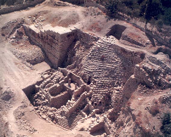
Sometime in the 14th to 13th centuries B.C.E., the Canaanites/Jebusites built the now famous Stepped-Stone Structure, internally consisting of a huge fill. This massive fill was constructed at the highest point in the city, which also happened to be at its extreme northern end, just inside the city wall. The Stepped-Stone Structure was built up over a steep slope descending to the Kidron Valley. It served as the vast foundation for an impressive artificial platform that added a level area of about 2,000 square feet at the top of the hill. It is probably on this level area that the Canaanite/Jebusite citadel called the Fortress of Zion (Metsudat Zion; 2 Samuel 5-7, 9) was built.2
The foundation of the Stepped-Stone Structure consisted of a complex system of skeleton walls that once ran along and across the slope, forming “boxes” that were then filled with stones. This created a massive and imposing fill structure. Kathleen Kenyon, the British archaeologist who dug in this area of the City of David in the 1960s, suggested that the fill structure should be identified with the Millo mentioned in the Bible. As Kenyon noted-
None of the translators of the Bible, down to those of the New English Bible, attempts to interpret the term [Millo; see 2 Samuel 5-9; 1 Chronicles 11-8], but simply transliterates it from the Hebrew, of which the basic meaning is “filling.” Many writers on Jerusalem have made suggestions about the building to which the authors of the Biblical accounts are referring. Some have suggested a tower, some the infilling of a ditch, and so on, in different places and for different purposes, and there has been no consensus of opinion.3
Kenyon suggested that the Millo is what has now become known as the Stepped-Stone Structure; she was doubtful, however, that other scholars would leap to agree with her- “No doubt my suggestion will equally fail to secure unanimous approval,” she wrote. “My candidate is at least certainly a filling that has been found, and equally certainly it was of great importance.”4
I think Kenyon was probably right. The link between the Millo and the fill structure known as the Stepped-Stone Structure is very appealing, not only because of the name “Millo” (i.e., “filling”) but also because of the location, which accords well with the Bible’s description of the Millo’s strategic importance to the City of David. Note, for example, how important the Millo was to Hezekiah’s defense of the city during Sennacherib’s siege in the late eighth century B.C.E. (2 Chronicles 32-5). From the reign of King Solomon onwards, the kings of Jerusalem had to rebuild and reinforce the Millo as a complex architectural unit of prime strategic importance (1 Kings 9-15, 24).5
With this background, let us see if we can determine where King David’s palace might be located.
Unlike his son Solomon, David was not a great builder. He was too taken up with wars and political affairs to concentrate on building projects. Nor did he have the architectural expertise for carrying out royal building projects.
The only royal building the Bible mentions as having been constructed in Jerusalem during his reign is his palace. But this was built for David by Hiram, king of Tyre (2 Samuel 5-11; 1 Chronicles 14-1). This gesture is widely recognized as a symbol of friendship between the Israelite monarch and his Phoenician counterpart as well as a recognition of the newly acquired importance of the kingdom of Israel and its new capital in Jerusalem. But Hiram’s gift also reflects David’s seeming inability to build a palace himself. Hiram sent not only cedar logs but also carpenters and stonemasons, doubtless because of their scarcity in the new Israelite capital. David resided in the Fortress of Zion, the old Canaanite/Jebusite citadel until his palace was built.
After David captured Jerusalem, Israel’s perennial enemy, the Philistines, could no longer restrain themselves. At this point, we need to look very carefully at the Biblical text- “When the Philistines heard that David had been anointed king over Israel, the Philistines marched up in search of David, but David heard of it and he went down to the citadel [or fortress; Hebrew, metsudah]. The Philistines came and spread out over the Valley of Rephaim” (2 Samuel 5-17–18).
David ultimately prevailed, but that is not our concern here. That the battle occurred at the Valley of Rephaim near Jerusalem indicates that David was already based in Jerusalem at this time. (During the first seven years of his reign, he ruled from Hebron.) When David heard that the Philistines were coming up to wage war against him, he went down to the citadel, that is, to the building on top of the Stepped-Stone Structure. Based on the topography of the site, it would appear that he heard the news of the Philistine advance from a point higher up than the citadel; thus his palace must have been north of the citadel.
Incidentally, there is no reason to doubt the accuracy of the Biblical description; the Bible is quite careful in its use of going up and going down. For example, upon hearing of the death of his rebellious son Absalom, David “went up to the chamber over the gate, and wept” (2 Samuel 18-33).
The obvious implication of this passage is that David was already living in his new palace when news arrived of the Philistines’ hostile approach. David’s palace was probably not fortified strongly enough to withstand a direct attack, so the king preferred to barricade himself inside the citadel until the situation improved.
Since the Canaanite/Jebusite citadel had been deliberately built on the city’s northern border, adjacent to the narrowest width of the ridge, David’s new palace must have been constructed both to the north of the citadel and outside the city’s fortified boundaries.
At first glance, this may seem illogical. Wouldn’t the king’s palace be built in the most defensible place within the city walls?
The problem was that the small 9-acre site that was Canaanite/Jebusite Jerusalem had already been built up; there was no room for him to build a palace inside the walls. When David conquered the city, it had already been inhabited for more than two thousand years, and it had been surrounded by a city wall for nearly a thousand years. Moreover, Jebusites continued to live in the city after David’s conquest. In short, after David’s conquest, the overcrowding in the city became even worse, with hundreds of David’s followers settling there. Kathleen Kenyon also noted this problem, although she did not locate David’s palace to the north of the citadel as seems to be required by the Biblical text. Instead, she suggested, his palace must have been very small- “David must have cleared a space within the Jebusite town, but the size of his residence is unlikely to have been great, for anything grandiose would have taken too much space within the restricted area of the Jebusite-Davidic city.”6
It is much more likely, I believe, that David decided to build his new palace outside the city walls. If so, he would probably have chosen a site adjoining the citadel to the north. This proximity would have been desirable for several reasons-
The areas to the south, on top of the ridge, were filled. The areas on the lower part of the slopes were not only difficult to build on but were far from the citadel and exposed to attack.
The site adjoining the citadel to the north was protected from the south by the citadel and on the east and west by the steep slopes descending to the Kidron and Tyropoeon valleys, which protected the rest of the City of David.7
Finally, David would probably have wanted his palace to stand near the center of royal activity in the citadel.
Like the rest of the City of David, however, this site outside the city wall was exposed from the north, where there were no natural defenses. This remained the weak point in strategic terms, especially in the event of war, although some sort of fortified structure would have met everyday security requirements. When war broke out, the structure would not have been strong enough to serve as a safe stronghold; indeed, when the Philistines came up to attack David, he abandoned his palace for the citadel, as already suggested.
King Solomon, David’s successor, built a new acropolis further to the north, on the Temple Mount. During the years following, the acropolis developed and was extended southward to the northern Ophel. The northern acropolis’ complex of royal buildings was called the “upper house of the king” (Nehemiah 3-25), implying that there must have been a “lower house of the king,” which was probably the old acropolis to the south, in the City of David, which preserved its sacred and royal character (see 2 Chronicles 8-11).
In 1962 Kenyon excavated immediately north of the Stepped-Stone Structure (her Square A XVIII), at the eastern foot of the area where I have placed David’s palace. She found a post-Exilic wall (fourth century B.C.E.) built on a scarp, which she describes as follows-
The scarp was intentionally created, for tool marks could be traced that showed it had been artificially formed. It was in existence earlier than the post-exilic wall that crowned it, perhaps in connection with the platforms on the slope, for beneath the [post-Exilic] 5th–3rd cent. deposits referred to was a level of collapse of very well-dressed masonry blocks, amongst which was a Proto-Ionic pilaster capital, in two fragments. Such capitals have been found for instance at Samaria and Megiddo and though they have in fact never been found in position, are accepted as typical of the best period of Israelite building, during which the use of Phoenician craftsmen was responsible for an exotic flowering of Palestinian architecture. It would seem, therefore, that during the period of monarchic Jerusalem, a building of some considerable pretensions stood on top of the scarp.8
Hebrew University archaeologist Yigael Shiloh, digging in the 1980’s (Shiloh’s Area G) next to Kenyon’s Square A XVIII found more of the dressed masonry blocks that Kenyon excavated.9 These dressed stones—and the proto-Ionic capital—must have tumbled down from the palace that once stood on the scarp. The artificially created rock scarp seems to have been designed to make access to the palace from this side even more difficult.
Lest the reader underestimate the significance of this proto-Ionic (sometimes called proto-Aeolic) capital, it is the most beautiful example of its type ever found in Israel.10 It is over 4 feet wide, 2 feet high and nearly 1.5 feet thick. Imagine the imposing column that supported it.
Shiloh dated this capital to the ninth century B.C.E., based on the development of its style and parallel exemplars.11 As Shiloh recognized, this stylistic development may have occurred as part of artistic work designed for the king’s palace in Jerusalem. However, there is no need to date it as late as the ninth century B.C.E.; it could easily be attributed to an earlier assemblage, as a particularly beautiful variant of this style. Another possibility is that the capital does date to the ninth century B.C.E. but was part of a repair of, or an addition to, David’s palace. David’s palace may have continued to be used, probably known as the “lower house of the king,” even after Solomon had built his new royal palace, known as the “upper house of the king.”
In her Site H, in the very area where I have placed King David’s palace, Kenyon found what I believe is additional evidence of royal architecture. Here is her description-
In the restricted area of site H, north of the line of the east-west complex that divides occupation of the Jebusite period from that which is probably tenth century B.C., the earliest wall that we found, based on bedrock, was of the casemate type, a type in which two parallel walls are linked by cross walls, thus creating small rooms within the wall complex. Such a method of constructing walls for the Solomonic period and at least into the ninth century B.C. is attested at Hazor, Megiddo, Tell Beit Mirsim, and Samaria. The Jerusalem Site H example has interior rooms of smaller size than elsewhere, but it certainly falls within the same category.12
Kenyon thought that these remains represented a casemate wall built by King Solomon in order to protect the acropolis.13 In my opinion, they are actually the remains of small palace rooms that originally enclosed a courtyard. This arrangement gave the palace the aspect of a small fortress (“What Did King David’s Palace Look Like?”).
Kenyon also discovered what seems to be the northeastern corner of the palace in Site H, although she failed to make the connection. The northern “casemate wall” (as she regarded it) did not extend as far as the crest of the hill. Instead it turned south. This suggested to her that the “casemate wall” she dated to the Solomonic period must have been the enclosure wall of a royal building, indeed, in her words, “a very important building”- “[At] the point at which, by pure chance, our excavations cut across the summit of the ridge, there was a very important building, which could well have been defensive, and which was subsequently added to either in the late Jebusite or early Israelite period.”14
Although she thought that these traces of construction belonged to a casemate wall from the Solomonic period, her words accord well with the hypothesis of this article, that in fact she had stumbled upon the corner of King David’s palace. Our dating techniques are not yet so refined that we can easily distinguish between the Solomonic period and the Davidic period in Jerusalem. Kenyon realized that these traces of construction were part of an important building, and as I have shown, they were found precisely in the area where King David’s palace was most likely located.
When Kenyon sought to excavate this area in the 1960s, she encountered insurmountable barriers when she expressed interest in digging north of Site H. Much of the area was occupied by orchards and gardens, making excavation very costly. Accordingly, she confined herself to a very narrow trench—only 3 meters wide and extending across the summit. Today, the land is available for excavation. The plots that cover this area are owned by the state and are barely built up at all. Who will heed the call to find King David’s palace?
1. Yigal Shiloh, Excavations at the City of David I, 1978–1982- Interim Report of the First Five Seasons, Qedem 19 (1984), p. 27.
2. Shiloh, Excavations, pp. 16, 26.
3. Kathleen Kenyon, Digging Up Jerusalem (New York- Praeger, 1974), p. 100.
4. Kenyon, Digging Up Jerusalem, p. 100.
5. Benjamin Mazar emphasized that his proposal to identify the royal building uncovered in his excavations on the Ophel as the “house of Millo” was purely hypothetical and in any case cannot be definitely linked to the Millo of David and Solomon. See Eilat Mazar and Benjamin Mazar, Excavations in the South of the Temple Mount- The Ophel of Biblical Jerusalem, Qedem 29 (1989), pp. ix–x. It is particularly surprising that Prof. Shiloh, the latest excavator of the fill structure in Area G of the City of David excavations, ignored the identification proposed by Kenyon and, following Prof. Mazar’s suggestion about the house of Millo, sought to locate the Millo in the area of the royal building found by Mazar on the Ophel. See Shiloh, “The City of David- 1978–1983,” in Biblical Archaeology Today- Proceedings of the International Congress on Biblical Archaeology, Jerusalem, April 1984 (Jerusalem- Israel Exploration Society, 1985), pp. 451–457.
6. Kenyon, Digging Up Jerusalem, p. 103.
7. Kenyon, “Excavations in Jerusalem, 1961,” Palestine Exploration Quarterly 94 (1962), p. 75- “Crowfoot’s excavations in 1927 showed that there was a depth of 56 feet of accumulation in it, and it originally demarcated the western side of the eastern ridge almost as sharply as did the Kidron Valley on the east.”
8. Kenyon, “Excavations in Jerusalem, 1962,” Palestine Exploration Quarterly 95 (1963), p. 16.
9. Shiloh, Excavations, p. 27.
10. In his study entitled The Proto-Aeolic Capitals and Israelite Ashlar Masonry (Qedem 11[1979], p. 10), Shiloh wrote, “The design of the outline and the lines of the relief of this capital are the finest of all the Proto-Aeolic capitals in this country.”
11. Shiloh, Proto-Aeolic Capitals, p. 11.
12. Kenyon, Digging Up Jerusalem, pp. 114–115.
13. Kenyon, “Excavations, 1962,” p. 17.
14. Kenyon, “Excavations, 1962,” p. 18.
Subscribe
If you enjoyed this article, subscribe to receive more just like it.


1 Comment on "Excavate King David’s Palace! Eilat Mazar, BAR 23:01, Jan-Feb 1997."
Trackback | Comments RSS Feed
Inbound Links