Philistine Kin Found in Early Israel, Adam Zertal, BAR 28:03, May-Jun 2002.
 Almost from the beginning, the site of el-Ahwat was different—or, shall we say, strange. We first discovered it in 1992 during our archaeological survey of the hill country of Manasseh in north-central Israel. Seven dig seasons later we would come to identify it not only by excavating the site, but by delving into ancient Egyptian and Ugaritic texts—and, especially, the Bible. Our studies also took us to the island of Sardinia, of all places.
Even before sticking a spade into the ground, we could see odd piles of rocks among the stone walls that protruded from the ground at the site. Strewn all around were potsherds that dated the site to Iron Age I, the period of the Israelite settlement and the invasions by the so-called Sea Peoples (c. 1200–1000 B.C.E.). Subsequent excavations confirmed both the dating and the unique character of the site—and eventually uncovered new information about the activities and influence of a lesser-known tribe of Sea Peoples in Canaan. In fact, our dig opened a whole new field of study that extended across the Mediterranean Sea and into Sardinia, Crete, Syria and Egypt.
El-Ahwat (“the Walls” in Arabic) is located on a beautiful high hill, overlooking the Mediterranean coast (the Sharon Plain) to the west, the Carmel range to the north and the western Samarian hills to the south. To the north is a well-known wadi (a usually dry river bed that floods occasionally in the winter), the ‘Aruna Pass of ancient Egyptian records, connecting the Mediterranean coast with the Jezreel Valley.
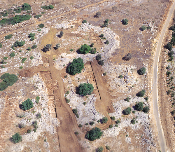
The site, which is relatively large (nearly 8 acres), was easy to distinguish from its surroundings. Its ground is hard and rocky and it lacks any source of water. In ancient times it was covered by a thick forest, patches of which still remain today.a It would have been difficult to live there, so we concluded that the site had been settled primarily for strategic reasons.
In the woods to the east and west of the site we discerned the remains of unusual fortification structures that differed from those found at any other Iron Age I sites in the country—in fact, they were unlike any regional fortifications from the second or first millennia B.C.E. For example, a square tower dated by Iron Age I potsherds seemed to have served to elevate the guard above the treetops. Such a configuration is rare in Canaanite and early Israelite sites.1
That tower was 600 feet to the west of another striking feature of the site- the city wall. The wall is unusually wide—18–24 feet—but still reaches a height of 15 feet in places. It is nearly 2,000 feet long and completely encircles the site except on the east, where a modern road cuts through it. The most surprising characteristic of the wall, however, is its unique, wavy design. Traditional Canaanite and Israelite cities such as Megiddo, Lachish and Hazor are protected by regular, rounded walls. Our city wall, in contrast, twists and meanders in a design that certainly was not dictated by the moderately sloping topography. The wall design was clearly an aesthetic choice that might indicate the influence of a foreign tradition. The wall design later proved to be crucial in helping us interpret our discoveries at the site.
Another curious—but helpful—characteristic of the site was that the settlement had only one stratum. This made it relatively easy for us to discern the town plan. In most digs archaeologists do not have access to the town plan as a diagnostic tool because the site has changed so much through generations of rebuilding.
Internally, the town easily divides into discrete sections, each one surrounded by inner walls, as shown in the site map. We labeled these sections, or excavation areas, with the letters A to E.
We were surprised to discover a strange emptiness in the town. Most of areas A and E, the largest in the site, were virtually unoccupied. Area C, where we found the remains of dwellings, had only one strip of houses along the city wall. Now that we have excavated about 50 percent of the site, we can see that most of the inner area was left empty. In contrast, all contemporaneous Canaanite and Israelite sites are tightly crowded with buildings, much like typical Middle Eastern villages today.
The mysteries didn’t stop there. The pottery and architecture found at el-Ahwat indicated that the site was inhabited for only a short time—about 50 years, from 1220 to 1170 B.C.E., give or take 10 years. We could see that whoever built the site did so on virgin soil. Once abandoned, the site was never again occupied, apart from some agricultural activity in the Late Roman and early Byzantine periods (135–500 C.E.). This early abandonment did not make sense. Approximately 200,000 cubic feet of stones were used for the wall alone. People don’t generally invest in a huge fortification project, use it for just 50 years, then leave and never come back. How to account for the short occupation of a settlement that had required such great effort to build?
What’s more, when the inhabitants left the site, they apparently took with them almost everything that was portable (except some tiny items, such as seals). On the floors we found only two or three restorable pottery vessels out of more than 15,000 isolated sherds we counted during the pottery processing. The inhabitants did not seem to flee in the face of a disaster, leaving their worldly goods behind, but carefully packed their belongings before departing.
Enigmatic remains continued to surface. The city gate street in the north section, for example, is unlike any among the known sites of that era, all of which require a person to ascend to the city gate by way of a ramp along the city walls. At el-Ahwat, however, one must descend when approaching the gate. The 15-foot-wide entrance itself is quite simple—an opening with a threshold and doorposts on flat stones—but no guardrooms or gate fortress, both of which typify contemporaneous gated entrances. Instead, a triangular, funnel-like plaza fronts the gate. This plaza measures 135 feet long and 45 feet wide at the center and is flanked by walls on either side. It narrows as it approaches the gate. On the outside of the “funnel” is a poorly preserved outer entrance.
The funnel-shaped, descending approach to the gate at el-Ahwat is unique among the Bronze and Iron Age sites of the ancient Near East—and it has no topographical justification. Again—a riddle.
As important as this site turned out to be, its excavation was not very exciting in the first years, when even small finds were rare. Where we began excavating, near the western city wall, we encountered about 3 feet of arable brown soil that contained Roman and Byzantine period (first century B.C.E. to seventh century C.E.) pottery sherds and small coins. The absence of any Roman or Byzantine architecture, however, led us to conclude that this rich soil had been imported by the new owners of the land some 1,500 to 1,600 years after the original settlers had abandoned the site. The landowners apparently dismantled the Iron Age houses and constructed terraces with the imported soil (presumably for growing olive trees) in the newly cleared space, using the worn-down city wall and the inner walls as retaining walls. The stones taken from the dismantled houses were placed in large piles.
Despite this unpromising start, as the excavation seasons passed, this remote, half-empty and short-lived site became a treasure-trove of small finds, some of great artistic value. This phenomenon amazed us. As early as the second season (1994), we found two Egyptian-style scarabs in area C. The first was inscribed in hieroglyphics with the name of Amun-re, the chief deity of Egypt in the New Kingdom (c. 1550–1084 B.C.E., roughly contemporaneous with Late Bronze and Iron Age I Canaan). The second showed a sitting lion and the Horus hawk, the symbol of Egyptian kingship. Both scarabs could be firmly dated to the XIXth Egyptian Dynasty (13th century B.C.E.), confirming the date we had previously arrived at based on pottery sherds. This also signaled that the site’s history began in the 13th rather than the 12th century B.C.E.
The next important find, made in 1996, was a beautiful black stone cylinder seal that was unearthed in area D. On it, a deity wearing a high Anatolian tiara stands on the back of a roaring lion in front of a tree, with a host of mythical creatures and other animals nearby. According to Baruch Brandl, a seal specialist with the Israel Antiquities Authority, this 13th-century B.C.E. scene has been seen on seals found in Ugarit, an ancient city on the Mediterranean coast of northern Syria, and on Hittite seals from Anatolia (modern Turkey).
But the real surprise came to light in the excavation of the northeastern, higher area of the site. On a flat terrace supported by a long retaining wall, we found a large building we call “the governor’s house.” It is 75 feet long and 36 feet wide, with walls 6 feet thick and a stone-paved courtyard in front. Most of the walls had been dismantled, but the floor had survived, along with many artifacts—including more Egyptian scarabs of the XIXth Dynasty, a small bronze statuette of a woman’s head (a goddess?) with a cap and large earrings, a square seal of black stone incised with a soldier on one side and a horse on the other, rings, large gold earrings, and silver, bronze and Carnelian beads. A particularly remarkable find was a beautiful ivory ibex head that closely resembles ibex images adorning vessels that often appear in Egyptian reliefs depicting Egypt’s diplomatic and trade relationships with its colonies or rivals. This ibex head, which is of unusually high quality, together with other artifacts found at the site, lead us to believe that the building had functioned as an administrative center with some connection to international trade.
The most significant find made inside the building, however, is a scarab with the royal name of Ramesses III of the XXth Dynasty (c. 1182–1151 B.C.E.), which told us that the site could not have been abandoned before the coronation year of Ramesses. It also raised other important questions. Was this the house of an Egyptian governor or perhaps a command center of a general? These questions remain unanswered.
Then there was the pottery problem. In general, two kinds of pottery are found in this region- hill-country (mainly Israelite) pottery—large, rough, undecorated vessels, including pithoi (large storage vessels), jars, cooking pots and kraters—and plains (Canaanite) pottery, found at such places as Megiddo, Taanach and Hazor. The latter are more delicate vessels (bowls, jugs and juglets) of pure whitish-greenish clay. But not one painted Canaanite sherd turned up. Nor did a single sherd of imported wares (Mycenaean or Cypriote). These locally produced and imported wares are found in almost every contemporaneous site in the Levant. Why not here?
The excavation of the residential areas (areas C and D) also revealed a different picture from what we would expect. Initially, the floors and walls seemed typical of Iron Age I hill-country dwellings- simple, packed, earthen floors strewn with bones and potsherds and walls built of one row of field stones. But the complexes were well planned, unlike the haphazard development characteristic of most hill settlements. There were no pillared houses, storage silos or water cisterns, all of which are ubiquitous in hill-country settings. Above all, the house plans were quite odd, differing in all aspects from any houses known in either the Bronze or the Iron Ages. Instead of the usual four-room house (Israelite) or courtyard house (Canaanite), we found strange complexes with labyrinthine rooms and walls with many built-in installations (such as jar bases, plastered storage spaces and bases for querns and grinding stones), all supported by or attached to the city wall or the inner walls of the settlement.
In the third season (1995), even stranger finds began to emerge. A special team, organized to investigate the walls and the fortification system, soon began to uncover a series of unusual corridors—narrow, well-built passages about 3 feet wide and 3 to 6 feet high, roofed by stone slabs or by a “false” or “corbelled” dome. (This type of roof is made out of rows of overlapping stones that together create a rounded, dome-like shape but do not have a constructed arch typical of “true” domes.) These corridors were entered from the houses and streets of the town. Two of the four corridors are straight and 12 feet long. A third, in area A, is very low and paved with slabs. The fourth, in area C, is oval and ends in a round room roofed by a false dome. At first we thought these corridors and round room could have been tombs, but they proved to be empty. Also, tombs do not usually open directly onto the streets of a town.
Then the team found several small, strange, stone igloo-like structures that resemble round buildings and tombs that are common in Greece, called tholoi (singular, tholos). Great stones had been assembled in layers to form a round structure about 10 feet in diameter and 6 feet high, with a false dome. The team later unearthed four more such structures around the site and completely excavated one of them. Such construction appears in the Roman period, but never in the Iron Age in the Levant. Because these odd structures were well integrated into the plan of the settlement and were clearly built at the same time as the rest of the site, they must be dated to the Iron Age.
We frankly did not understand the origin of the strange town wall design, the unusual approach to the gate, the corridors in the houses or the pottery. Nor had we any idea about the meaning and origin of the tholoi. Our search for parallels at other sites in the Levant—Greece, Anatolia (modern Turkey), Syria, Egypt—yielded not a clue. Given all these characteristics, we thought we had stumbled upon some new and different ethnic group, but we were unable to identify it. All we could do was rule out the Israelites, Canaanites, Egyptians and Philistines.
During the last week of the 1995 dig season, Professor Michael Heltzer, a distinguished historian from the University of Haifa, visited the site. We brainstormed with him, laying out the facts and asking for new ideas. Heltzer suggested that we go farther afield and check affinities between our material and the nuragic culture of Sardinia, a large, mountainous island off the western coast of Italy south of the island of Corsica. An initial examination immediately revealed parallels. Evidently, our settlement in Israel had been built by people who had connections with, or knew the traditions of, Sardinia’s nuragic culture.b
We are now tentatively able to identify our site as belonging to the Shardana, one of the lost and largely forgotten Sea Peoples who arrived on the Levantine coast long before the invasion of a better known group of Sea Peoples, the Philistines. We can also follow parts of their story, demonstrating their Sardinian origin and their covert role in shaping the Biblical narrative.
The nuragic culture takes its name from the nuraghi (singular, nuraghe), ancient constructions that dot the island of Sardinia. Nuraghe in Sardic (the ancient language of Sardinia) means, simply, “heap of stones.” The nuraghi vary in size and are built of stone. Sometimes they are rounded, but most often they are irregular or wavy in design and have corbelled roofs. They always contain curving corridors that connect the rooms, and the more developed structures even have staircases. More than 6,500 nuraghi have been found in Sardinia.
Unfortunately, not much is known about the prehistory of Sardinia. The first proto-nuraghi were built in about 2000 to 1500 B.C.E., but the nuraghi did not attain their “golden age” until about 1500 to 1200 B.C.E. Written records of the island’s history begin only with the Phoenician seamen and traders who landed there in about 800 B.C.E. By then, the nuraghi were already archaic monuments of a largely forgotten civilization.
Scholars differ sharply as to the function of the nuraghi. Some of the most elaborate nuraghi look like medieval castles three stories high, with an inner labyrinth of corridors and rooms roofed by a false domes. Certain nuraghi (there are fields of them) resemble villages, with tholoi grouped around a central tower.
After we had learned about the similarities between our site in Israel and nuragic architecture in Sardinia, I went to Sardinia for the first of several visits to consult with Professor Giovanni Ugas of the University of Cagliari, in the island’s capital. (We later hosted 40 students from the University of Cagliari, who worked with us for two seasons at el-Ahwat, and they graciously hosted 12 people from the University of Haifa during a two-week tour of Sardinia.)
As we studied the evidence, we grew more and more convinced that the inhabitants of el-Ahwat knew Sardinia well. Probably they—or their ancestors—had originated there.
Professor Ugas helped me distinguish between the early proto-nuraghi (irregular, low constructions with no towers) and the classic nuraghi. The proto-nuraghi of Sardinia distinctly resemble the structures we had found at el-Ahwat, both in design and proportions, although ours are smaller. They are built of several stone courses, with corridors and tholoi inside. Making due allowance for differences in locally available construction materials and topography, it is clear that key characteristics of Sardinian architecture were fully preserved at el-Ahwat, although our structures also include local architectural design elements.
Take, for example, our town plan. As far as we know, rather few Sardinian nuraghi were enclosed in walls. Town walls, however, have a long history in the Levant. The builders of el-Ahwat adopted this Levantine tradition, but incorporated a proto-nuraghi wavy design similar to what they had known at home or through their own cultural tradition.
The pottery we found at el-Ahwat also seems to be almost completely local, except for one large bowl with a decorated rim. This decoration closely resembles Sardinian decoration—but similar decoration has been found in other Iron Age I sites in Israel. So the matter needs more study.
But corridors and corbelled domes like those at el-Ahwat are hardly seen outside Sardinia. The tholoi of Mycenaean Greece have false domes, as do some Late Bronze tombs in Ugarit and even in Megiddo. But corridors like ours, particularly in combination with false domes, exist in Sardinia, neighboring Corsica and the Balearic Islands east of Spain—and nowhere else.
Thus we were forced to conclude that el-Ahwat must have some cultural connection to Sardinia. We base this interpretation on much evidence—but the most compelling argument arises from the process of elimination. If the cultural connection with Sardinia is not valid, is there an alternative connection that would explain what we have found? In my best judgment, the answer is no. Parts of our interpretation do, however, remain theoretical and require further investigation.
Who, then, were the Shardana, the Sea Peoples tribe that we believe brought all these elements to el-Ahwat?c
“Sea Peoples” is a term coined by the French Egyptologist Gaston Maspero in 1882. Reading the inscriptions of Ramesses III, Maspero dubbed the enemies of Egypt les peuples de la mer (the peoples of the sea). He was referring to the waves of diverse peoples who invaded Egypt by land and sea during the 12th century B.C.E. The Egyptians called them “those of the deep green [that is, the sea].” The term “Sea Peoples” stuck, however, and is now frequently used by both scholars and lay people to include not only the groups attacking Egypt, but several other groups appearing in various sources. The Philistines are the best known of the Sea Peoples because they are so frequently mentioned in the Bible, but in Egyptian and other records of the ancient Near East, the Shardana are mentioned even more often.
Egyptian sources name at least nine different Sea Peoples- Akawasha, Danuna (Denyen), Tursha, Shardana, Shekelesh, Lukka, Sikulu (Tjeker), Weshesh and Peleset (Philistines). Scholars have long debated the origin of these groups.d At least some of them came from the Aegean area, which includes Mycenaean Greece as well as western Anatolia. The Bible tells us that the Philistines came from Caphtor (Amos 9-7), the island of Crete. The origin of other Sea Peoples has been suggested on etymological grounds- Maspero connected the Sikulu to the island of Sicily, and the Danuna to the Greek Danaans. In the same way, the Shardana have been related to Sardinia. But there has never been any concrete evidence for the connection, because the Shardana themselves did not write. Thus far, archaeology has done little to solve this problem.
Egyptian inscriptions indicate that the Shardana were mainly mercenary warriors, but were also settlers and merchants. They are first mentioned in the 14th-century B.C.E. el-Amarna letters as mercenaries of Rib-Adi, the prince of the cosmopolitan Levantine coastal city of Byblos. Later, they serve the prince of Ugarit, on the Mediterranean coast north of Byblos. In Ugarit, a prosperous city in northern Syria, they settled, purchased land, married local women and became citizens.
The Shardana are mentioned again in the 13th century B.C.E., as mercenaries in the private guard of the great Pharaoh Ramesses II (c. 1279–1212 B.C.E.). These Shardana soldiers apparently enjoyed a high status in the Egyptian army, equal to the Egyptians themselves. No other outsiders were given such prominence.
The Shardana also appear in the inscriptions of Mer-en-Ptah (or Merneptah, 1212–1202 B.C.E.), the son of Ramesses II, who described his battles against a coalition of Libyans and Sea Peoples. The Shardana seem to have fought on both sides, both for and against Egypt.
Unlike the Shardana, the Philistines are rarely mentioned in Egyptian records, which trace their early history for a period of only 80 years. The Shardana, on the other hand, have a recorded history of over 250 years.2
Both the Philistines and the Shardana are shown in reliefs carved on the eastern wall of the mortuary temple of Ramesses III at Medinet Habu, opposite modern Luxor in Upper Egypt. The scene depicts a battle on land and sea between the Sea Peoples and the Egyptians that occurred in the eighth year of the pharaoh (c. 1174 B.C.E.). The accompanying hieroglyphic inscriptions name the Philistines, Tjeker (Sikulu), Shekelesh, Denye(n) and Weshesh—but not Shardana. The reliefs do, however, show the Shardana, who wear distinctive headgear—a helmet with two horns—as we know from other reliefs with inscriptions on the walls of the temple that specifically identify them. (Nuragic bronze statuettes of warriors with similar horned helmets have also been found in Sardinia—but these statuettes appear to have been produced 200 years after the original Shardana. Perhaps they preserve a long Sardinian tradition of horned helmets.) Two out of five of the Sea Peoples’ ships are loaded with these Shardana warriors. The other three ships are loaded with warriors wearing feathered headgear, symbolizing other Sea Peoples, including the Philistines.
The Shardana apparently hired out their services to whoever would pay them. When they are shown fighting against their brethren in the rows of the Egyptian army, they are identified by discs on their helmets between the horns. Their skirt and weapons, however, are identical to the other Sea Peoples’- a spear, a long, straight sword, a round shield and what looks like a distinctive ribbed skirt.
Following his victory over the Sea Peoples, Ramesses III tells us (in Papyrus Harris I) how he dealt with them- “I slew the Denyen in their islands, while the Tjeker and the Philistines were made ashes. The Shardana and the Weshesh of the sea were made nonexistent, captured all together and brought in captivity to Egypt like the sands of the shore. I settled them in strongholds, bound in my name. Their military classes were as numerous as hundreds-thousands. I assigned portions for them all with clothing and provisions from the treasuries and granaries every year.” This papyrus was probably written soon after the battle; it indicates Egyptian policy towards defeated enemies- They settled them and transformed them into Egyptian mercenaries.
Two other important texts were written by Egyptian priests who traveled to Canaan on different missions about the same time—around 1100 B.C.E.—some decades after the battle described by Ramesses III. The first priest, Wen-Amun, sailed along the eastern Mediterranean coast and anchored at Dor, a city he says was the center of the Sea People, known as Sikulu.e The second Egyptian priest, Amenope, traveled by land. He describes three Sea Peoples that settled in Canaan. Traveling from the south to the north he encountered, in this order- the Philistines, the Sikulu and the Shardana. On the basis of this order, the great German historian, Albrecht Alt, following the pioneering American Biblical archaeologist, William F. Albright, concluded that the Shardana probably settled in the bay of Akko.3 As our findings indicate that the Shardana had in fact settled further south and inland, this theory now seems to be disproven.
How might we account for the presence of Egyptian artifacts in the Shardana settlement at el-Ahwat? Perhaps the settlement was established as an Egyptian fort (with an Egyptian governor) and staffed with Shardana soldiers, as described in the Ramesses III papyrus already cited. Or it may have been an independent Shardana colony over which Egypt exerted a strong influence.
Having located the Shardana archaeologically, we were, of course, tempted to see whether they turned up in the Bible. I discussed the possibility during my first visit to Sardinia, over lunch with Giovanni and Christina Ugas. If the Shardana are in the scriptures, what would they have been called? For generations, scholars supposed that the term “Philistines” included all the other Sea Peoples, but the Bible calls every Canaanite tribe by name—why not the Sea Peoples as well?
The list of the peoples of the world in Genesis 10-5 includes certain iyei ha-goyim. In Biblical times the word goy (plural, goyim) simply meant “nation.” Iyei is a Hebrew construct form of “islands.” This phrase has been variously translated “islands of the nations” (NJB), “coastland peoples” (NRSV), “maritime islands” (NAB) and “maritime nations” (NJPS); the idea is the same. Albright, however, was the first to connect goyim with the Sea Peoples.4 (He was later followed by Benjamin Mazar and others.5) In 1923 he wrote-
Goyim is a term applied in our oldest sources to migrating hordes … [and] also to the migrating Sea Peoples, as in ‘Harosheth of the Nations’ [Harosheth ha-goyim in Hebrew] … It may then be that the basin of the ‘Aujah [‘Aruna] was occupied about 1200 B.C. or a little earlier by a branch of the same people to which Sisera and his hordes belonged. If this is the case, we may safely assume that the Philistines and Sicilians avoided the ‘Aujah Region because it was already held by a related folk.
I suggest that the “related folk” Albright mentions here were the Shardana.
But where was Harosheth? And how does Sisera fit in?
The Book of Judges tells us that Sisera was the general in command of the army of the Canaanite king of Hazor, named Jabin. Sisera lead Jabin’s army in a critical battle against the Israelites, whose general, Barak, was called to battle by Deborah, a female judge. This battle was so important that it is described twice, once in prose (Judges 4) and again in poetry (Judges 5).6 One might assume that Sisera was Canaanite because he commanded the army of a Canaanite king (Jabin). But as Albright also observed, Sisera’s “name sounds neither Semitic nor Hittite.”7 Neither is it Egyptian. What is it? Where did he come from? As we have seen, Albright had long ago guessed that Sisera was a leader of the Sea Peoples—but the eminent scholar never followed up on the idea.
I first encountered the possible origin of Sisera one day while driving in Sardinia. The name of the second most important city of the island is Sassari. Suddenly it reminded me of Sisera. If the Shardana originated in Sardinia, why couldn’t Sisera be their commander, his name deriving from Sassari?
Years ago, an Italian scholar named Giovanni Pugliese Carratelli published a tablet from the island of Crete, from the 14th century B.C.E., that came from a nuragic settlement. On the tablet was a name—Seisara, almost identical to Sassari/Sisera.8
In my search for Sisera, I then looked eastward, to the Shardana colony at Ugarit. Among the extensive material from the archive was the name of a prince in the 14th century B.C.E. called Zi-za-ru-wa or Si-sa-ru-wa. 9
Now I had a chain of evidence- the name, originating in Sardinia, wandered (with the Shardana?) first to Crete and then to the eastern Mediterranean. Indeed, the name Sisera resembles the most common Sardinian dynastic name, the first vowel of which is Sa or Si, as in sa Corona, for example.
If I am right so far, Harosheth ha-Goyim, Sisera’s military base in Canaan (Judges 4-2), should be understood as the city of Harosheth of a particular tribe of the Sea Peoples, namely the Shardana, originally from Sardinia. But where in Canaan was this Harosheth?
The site has never been found. Many scholars have tried in vain to locate it. There has never been even one good candidate—until now. I think that our site, el-Ahwat, is most probably Sisera’s base, Harosheth ha-Goyim. It is a fortified, short-lived settlement, inhabited by the Shardana (goyim- northern Sea Peoples). In ancient times, the mountain on which it is located was covered with a forest. This is significant in light of Mazar’s linguistic study of the name Harosheth. He related it to Hebrew horesh and Ugaritic hurshanu—both of which mean “forest.”10
This identification gives Harosheth ha-Goyim its geographical setting and explains the strategy described in Judges 4-6–7. Deborah says to Barak- “The Lord, the God of Israel, has commanded- Go, march up to Mount Tabor, and take with you ten thousand men of Naphtali and Zebulun. And I will draw Sisera, Jabin’s army commander, with his chariots and his troops toward you up to the Wadi Kishon; and I will deliver him into your hands” (NJPS).
The location of the battle is further specified in the poetic account in Judges 5-19–21-
Then the kings came, they fought-
The kings of Canaan fought
At Taanach, by Megiddo’s waters—
They got no spoil of silver.
The stars fought from heaven,
From their courses they fought against Sisera.
The torrent Kishon swept them away,
The raging torrent, the torrent Kishon.
March on, my soul, with courage!
The battle occurred somewhere between Taanach and Megiddo, southwest of the Kishon. The Israelites prepared for battle on Mt. Tabor, about 15 miles east of the Kishon River. They must have marched west to arrive at the battlefield at Taanach—while Sisera must have been “drawn” (mashakh) toward them from the opposite direction, that is, from the west. The two armies would have met in the middle at Taanach, west of the Kishon. In this way, the text offered the clues that finally convinced me that el-Ahwat is situated exactly in the right place to be Harosheth ha-Goyim.
The Israelites fought the famous Battle of Deborah against a coalition led by the Shardana of Harosheth ha-Goyim/el-Ahwat. The coalition was headed by Sisera, whose name originated in Sardinia. The Shardana forces descended from el-Ahwat down to the ‘Aruna Pass and then moved eastward toward the battleground. There, in the mouth of the pass, between Taanach and Megiddo, they must have been caught by surprise by the Israelites.
The Biblical text tells us that Sisera “had 900 iron chariots.” This also supports our theory. The Philistines, another of the Sea Peoples, apparently controlled iron manufacture. Even as late as King Saul’s time, the Bible tells us, “No smith was to be found in all the land of Israel, for the Philistines were afraid that the Hebrews would make swords or spears. So all the Israelites had to go down to the Philistines to have their plowshares, their mattocks, axes, and colters sharpened” (1 Samuel 13-19–20).f
The Shardana chariots were mobile—much more mobile than foot soldiers—but they were also heavy and slow, and were only effective on the plain and not in hilly terrain.11 I believe the Shardana chariots were ambushed as they moved single-file through the narrow ‘Arunah Pass just where it opens into the vast plain of the Jezreel Valley.
This was exactly what happened to the army of Pharaoh Thutmosis III 300 years earlier at a famous battle at Megiddo, as described in reliefs carved at the walls of the Temple of Karnak- “What is it like to go in this road, which becomes so narrow? Will not horse have to go after horse, and the army and people similarly.”12 This best explains how Israelite hill-country farmers, armed only with sickle swords and primitive weapons, could defeat some of the best warriors of the ancient world—the Shardana charioteers.
Sisera’s army fled back toward their home base—Harosheth ha-Goyim/el-Ahwat. On the way they were slaughtered by Barak’s ragtag army of Israelites (Judges 4-16). Sisera found his own chariot useless. The text tells us that “Sisera leaped from his chariot and fled on foot” (Judges 4-15). Instead of returning to camp, however, he fled eastward to seek protection from Heber the Kenite, a friend of King Jabin of Hazor (Judges 4-17). There the exhausted Sisera soon fell asleep and Heber’s wife, Yael, dispatched Sisera by pounding a tent peg into his temple (Judges 4-21).
This battle was of enormous importance and yet I believe it has never been fully understood. It was the beginning of a critical struggle between the Sea Peoples and the Israelites, a war later taken up by the Philistines. The Jezreel Valley linked the Josephite tribes, Manasseh and Ephraim, with the Galilee tribes of Zebulun and Naphtali. Had the Israelite tribes not been able to control the Jezreel Valley, the Shardana-Canaanite coalition would have broken the alliance between these two northern Israelite groups.
This also explains why el-Ahwat was so short-lived and why it was abandoned in the first half of the 12th century- Following their defeat, the Shardana were forced to withdraw from their remote fortress and settle elsewhere along the Mediterranean coast13—where they quickly exited the stage of history. After their single and final defeat, the mercenary warriors assimilated into Canaanite culture—a fleeting episode, important in their time, but short-lived. But had they prevailed, the history of ancient Israel might have been far different.
The excavations at el-Ahwat have revealed much that is new about the Shardana, an ethnic group whose origins can now be identified by architectural elements that are unique to Sardinia. I do not think these Shardana came to the Levantine coast directly from Sardinia. They probably stopped elsewhere first—perhaps Crete, Egypt and Ugarit—and absorbed local traditions of pottery making and foreign town planning that we see at el-Ahwat. This model comports well with all immigrant communities, which retain some of their old traditions but also adopt new local ones.
I am inclined to see the Battle of Deborah as a critical encounter between the northern Israelite tribes and the northern Sea Peoples (the Philistines being further south). Fortunately, the Israelites won the battle, which has forever been enshrined in one of the great Biblical poems (Judges 5), as well as in a stirring prose version (Judges 4). Our discoveries at el-Ahwat offer a new explanation of the dynamics of the battle and its geography.
If this reconstruction is correct—and the picture, of course, has many gaps and unanswered questions—then there must have been an organized coalition of Israelite tribes by the beginning of the 12th century B.C.E. This is consistent with the view I have previously expressed—that by that time the tribes had already coalesced around their cultic center on Mt. Ebal. Here again we see a kernel of historical events embedded in the early literary narratives of the Bible, a history that some in the scholarly community today would deny.
El-Ahwat is one of three digs that make up the Northern “Sea Peoples” Project, run by Haifa University with the University of Cagliari, Sardinia. Tel Assawir, a sister dig of el-Ahwat, welcomes volunteers this summer, July 7th–August 1st, 2002. See our Web site or check the BAR Digs Guide, January/February 2002.
Raphael Kimchi, Ron Beeri (both Univ. of Haifa) and Professor Giovanni Ugas (Univ. of Cagliari, Sardinia) supervised the excavation of the governor house; Amit Romano and Nirit Lavi-Alon (both Univ. of Haifa) supervised the excavation of the residential areas; Dror Ben Yosef (Univ. of Haifa) headed the special fortifications and wall team.
a. For more on the Manasseh survey, see Adam Zertal, “Has Joshua’s Altar Been Found on Mt. Ebal?” BAR 11-01 and “Israel Enters Canaan—Following the Pottery Trail,” BAR 17-05.
b. See Joan B. Scheuer, “Volunteer’s Report- Searching for the Phoenicians in Sardinia,” BAR 16-01.
c. See Avner Raban and Robert R. Stieglitz, “The Sea Peoples and Their Contributions to Civilization,” BAR 17-06. See also William H. Stiebing, Jr., “When Civilization Collapsed—Death of the Bronze Age” AO 04-03, and “Invasions of the Sea Peoples,” AO 04-03.
d. See Trude Dothan and Seymour Gitin, “Ekron of the Philistines, Part I- Where They Came From, How They Settled Down and the Place They Worshiped In,” BAR 16-01. See also Bryant G. Wood, “The Philistines Enter Canaan,” BAR 17-06.
e. See “On a Mission from God” AO 02-03 (excerpt from James B. Pritchard, ed., Ancient Near Eastern Texts Related to the Old Testament [Princeton- Princeton Univ. Press, 1969], pp. 25–29).
1. The only other example is a tower that has been found at Giloh—and that seems to support our case. See Amihai Mazar, “Iron Age I and II Towers at Giloh and the Israelite Settlement,” Israel Exploration Journal 40- 2–3 (1990), pp. 77–101.
2. Shardana appear in Egyptian and Ugaritic sources and probably in the Bible as well. See A. Loretz, “Les Sardanu et la fin d’Ugarit, a propos des documents d’Egypte, de Byblos et d’Ugarit relatif au Shardana,” in Le pays d’Ugarit autour 1200 av. J.-c., colloque international, Paris, 28 Juin-1 er Jouillet, 1993 (Ras Shamra XI), ed. M. Yon, M. Scznycer and P. Bordreuil (Paris, 1995), 126–135. In the same volume, see A. Kahl, “Les temaignage textuelle Egyptiennes sur les Shardana” (addendum to the Loretz article).
3. William F. Albright, “Contribution to the Historical Geography of Palestine,” Annual of the American Schools of Oriental Research 2–3 (1922–23), pp. 1–46; see also Albrecht Alt, “Syrien und Palaestina im Onomastikon des Amenope,” Schweizerische Theologische Umschau 20 (1950), pp. 58–71.
4. Albright, “Some Archaeological and Topographical Results of the Trip Through Palestine,” Bulletin of the American Schools of Oriental Research 11 (1923), pp. 8–9.
5. Benjamin Mazar, “Beth-She’arim, Gaba and Harosheth of the Gentiles,” Hebrew Union College Annual 24 (1952–1953), pp. 75–84.
6. Prose and poetry frequently appear together in the literature of the ancient Near East. For instance, the Israelite Song of the Sea (Exodus 15-1–21) is a celebratory Biblical poem that follows a prose description of the Israelites’ miraculous crossing of the Sea of Reeds (Exodus 13-17–14-30). See also the alternating prose and poetry text of “Hymn of Victory of Mer-ne-Ptah (The ‘Israel Stela’),” in James B. Pritchard, ed., Ancient Near Eastern Texts Related to the Old Testament (ANET), (Princeton- Princeton Univ. Press, 1969), pp. 376–378.
7. Albright, Yahweh and the Gods of Canaan- A Historical Analysis of Two Contrasting Faiths, (London- Athlone, 1968), p. 216, n. 217.
8. Giovanni Pugliese Carratelli, “Seisara,” La Parolla del Passato 166 (1976), pp. 123–128. See also G. Garbini, “Il Cantico di Debora,” La Parolla del Passato 178 (1978), pp. 5–31.
9. Albright, Gods of Canaan, p. 216, n. 217.
10. Benjamin Mazar, “Gaba and Harosheth of the Gentiles,” in Cities and Districts in Eretz-Israel (in Hebrew) (Jerusalem- Bialik Institute, 1975), pp. 110–121.
11. Robert Drews, The End of the Bronze Age- Changes in Warfare and the Catastrophe ca. 1200 B.C. (Princeton- Princeton Univ. Press, 1993), pp. 48–76.
12. Pritchard, “The Asiatic Campaigns of Thut-mose III—The First Campaign- The Battle of Megiddo,” in ANET, p. 235.
13. Since 1996, other settlements with Sardinian architecture have been discovered in the southern Carmel range, some 15 miles north-northwest of el-Ahwat. See Adam Zertal, “The ‘Corridor Builders’ of Central Israel- Evidence for the Settlement of the ‘Northern Sea Peoples,’” in Defensive Settlements of the Aegean and the Eastern Mediterranean After c. 1200 B.C., ed. Vassos Karageorghis and Christine E. Morris (Dublin/Nicosia- Trinity College Dublin/Anastasios G. Leventis Foundation, 2001), pp. 215–232. I believe we can now speak of a Shardana territory, parallel to a Sikulu territory, centered at Dor.
See also-
Queries and Comments- Philistine Kin, BAR 28-05, Sep-Oct 2002.
Subscribe
If you enjoyed this article, subscribe to receive more just like it.


