Excavating the Tribe of Reuben, Larry G. Herr and Douglas R. Clark, BAR 27:02, Mar-Apr 2001.
 A four-room house provides a clue to where the oldest Israelite tribe settled.
We were lucky. There’s no other way to explain it. When our archaeological survey team, part of a larger expedition known as the Madaba Plains Project, discovered Tall al-‘Umayri1 in 1976, we had no idea it would yield great treasures.2 But now, almost 25 years later and after seven excavation seasons (beginning in 1984), we can only stand back and marvel as the Holy Land’s best-preserved site from the time of the Judges slowly emerges from beneath more than three millennia of accumulated dust and debris.
Tall al-‘Umayri lies in the highlands of Transjordan (the part of the Holy Land east of the Jordan River and the Dead Sea) just south of Jordan’s capital, Amman. We naturally wanted to know who lived there in Biblical times. Could they have been, we wondered, the Ammonites, the enemies of King Saul and King David (1 Samuel 11 and 2 Samuel 10)? The Ammonites were the most prominent people in the region during the time of the monarchies of Israel and Judah. They also gave their name to the modern city of Amman.
Or could the inhabitants of ‘Umayri have been the Amorites, whom the Bible says Moses and Israel encountered at Heshbon and then destroyed on their way to the promised land (Numbers 21)?
How do our finds affect the scholarly discussion of the settlement processes of the various tribal groups—including Israelites, Ammonites and Moabites—during the time of the Judges? These groups were making the transition from tribal lifestyles to complex monarchies during the last two centuries of the second millennium B.C.E. and the first few centuries of the first millennium B.C.E.
We believe the most likely people to have settled our region and built ‘Umayri were not the Ammonites or the Moabites, but rather the Reubenites (Joshua 13-8–10). The evidence is not conclusive, but we believe it is persuasive.
Reuben was the oldest son of the patriarch Jacob. He was hardly an ideal role model for his younger brothers, however. His father, Jacob, cursed Reuben (Genesis 49-4) for sleeping with one of Jacob’s wives (Genesis 35-22). Elsewhere, Reuben seems to have been a more positive force in the family- He picked mandrakes3 for his mother, Leah, to help her attract Jacob so that she could bear him more children (Genesis 30-14). He prevented his brothers from killing Rachel’s son Joseph by urging them instead to throw Joseph into a pit (Genesis 37-21–22) and then was genuinely heartbroken when it was later discovered that Joseph was missing (Genesis 37-29). And when Joseph, unrecognized by his brothers, demanded that they return to Egypt with Rachel’s other son, Benjamin, Reuben, to persuade Jacob to allow Benjamin to go, said that Jacob could kill Reuben’s own sons if Benjamin did not return safely (Genesis 42-37).
According to Numbers 32 and Joshua 13, the tribe of Reuben was allotted land east of the Jordan River, provided the Reubenites would help the rest of Israel conquer the promised land west of the Jordan. This they did (Joshua 4-12–13). The precise borders of Reuben are somewhat vague, however- Deuteronomy 3-12 and 3-16 indicate that Reuben and Gad extended north from the Arnon River (Wadi Mujib) to Gilead. The tribe’s territory also included Heshbon (modern Hisban), Madaba and Dibon (modern Dhiban), and its western border was the Jordan River (Joshua 13-8–10, 15–23).
The primary argument for the tentative identification of our findings with the tribe of Reuben are the Biblical references to Reuben in this area.
Anthropologists tell us that genealogies have social, political and religious significance; they are not simply lists of parents and children. Frank Moore Cross, the teacher of one of the authors (Herr) and the dean of Near Eastern orientalists, infers that Reuben played a dominant role in the early tribal confederacy known as Israel because Reuben is always named first in the Biblical genealogies of the sons of Jacob and in the lists of the Israelite tribes.4 Cross notes, however, that this primacy was true only during the early period of Israel’s emergence (Iron Age I, 1200–1000 B.C.E.). By the second half of this period (the 11th century B.C.E.), power and influence had shifted to the tribes west of the Jordan River. And by the tenth century B.C.E., the tribe of Reuben seems to have disappeared.
Based on a complex analysis of Biblical texts, Cross further suggests that both Reuben and Moses had a special connection with the Midianites, whose homeland and distinctive painted pottery have recently come to light in a series of 13th- and 12th-century B.C.E. oasis settlements in the Hijaz (northwestern Arabia). Midianite pottery is found as far north as southern Jordan and Israel.
Participation in the trading system of the Midianites along one of the most important trade routes in the Holy Land, the King’s Highway east of the Great Rift Valley, may have allowed the Moses/Reuben group to settle and prosper earlier than the other tribes.
Cross notes the absence of any archaeological remains from the 13th to 12th century B.C.E. in the Sinai.a He suggests, therefore, that Biblical Mt. Sinai was probably located in the Hijaz, where there is extensive evidence of habitation at this time.
Cross also supports his view with a philological analysis of some very early Biblical poetry. He notes that in the oldest poetry in the Bible, Yahweh, the Israelite God, is said to have come from this same region (which includes Se’ir [Judges 5-4] and Teman [Habakkuk 3-3]). Moreover, a Midianite, Jethro, was Moses’ father-in-law. Mt. Sinai was close to where Jethro lived, according to the Bible (Exodus 18).
Cross concludes that Reuben was a staging area for Israel’s entrance into Canaan.
Do Cross’s ideas, called the Reubenite hypothesis, help us to understand Tall al-‘Umayri?
Conversely, can our findings at ‘Umayri help us evaluate Cross’s hypothesis? If we formulate predictions based on his hypothesis and test them with the archaeological finds, perhaps we can suggest some answers to our questions.
The Reubenite hypothesis predicts that there should be a cluster of related sites in the region of Transjordan south of Amman, which is the core territory in all the references to Reuben; these sites should be somewhat earlier than those west of the Jordan if Reuben was the first to settle, as Cross suggests; and the sites should be somewhat larger and wealthier than those in the west if they hosted the tribe that was the leader of the confederation.
These three predictions admittedly cannot be tested with absolute certainty because archaeological finds are only circumstantial evidence—there may be more than one way to interpret the finds.
We will examine these predictions below. But first we need to discuss the spectacular finds from Tall al-‘Umayri and its region.
The transitional period between the Late Bronze Age and the early Iron Age (the late 13th to early 12th centuries B.C.E.) is represented at ‘Umayri by two settlements- a short-lived one that was destroyed by an earthquake around 1200 B.C.E.5 and a rebuilt town with beautifully preserved houses and a fortification system. We know very little about the earlier settlement except for its pottery, which was found in layers that date to before the earthquake.
After the earthquake, the inhabitants invested their energy and resources into rebuilding and defending their town, no doubt realizing that they were in a strategic location. They were located at the point where the hills met the fertile Madaba Plain, and they controlled the only water source between Amman and Madaba. The occupants therefore set about creating a strong fortification system that they hoped would keep attackers at bay.
Their work was in vain- The site was destroyed by a military force not long after it was rebuilt. (We have even found the bronze and stone weapons used in the clash.) This was bad news for the town’s populace, of course, but good news for those of us assigned to piece together their lives- The destruction buried the site under 6 to 8 feet of protective rubble, thus preserving it for us to find as it was on the day it fell.
What did the attackers encounter as they charged the city? If we could follow them (from a safe distance, of course), what might we discover about this well-fortified highland settlement? A ridge joined ‘Umayri to the hills on its western side. The ridge was only 20 feet below the level of the town and would have been a good place from which to attack the city. For this reason, the defenses on the western side of the town received the greatest investment of time and energy.
Assailants who attacked from the west first faced a dry moat 13 feet deep and 35 feet across, cutting the ridge close to where it joined the town. If they managed to slip down the rugged bedrock to the base of the moat and reach the other side, they would still be faced with a high stone wall along the eastern side of the moat, founded on massive boulders. This retaining wall, built on a 72 degree slope, stood 16 feet high and was constructed to support a steep beaten-earth rampart, or artificial hill, that sloped up to the town’s perimeter wall.
The rampart itself was built at considerable expense and with consummate skill. Its 35 degree slope presented a significant hurdle because it was covered with slippery fine clay, ash and bits of charcoal. Attackers, having cleared the moat and retaining wall, would still have to struggle up 50 feet of rampart fully exposed to those protecting the town from the top of its perimeter wall.
The perimeter wall above the rampart was between 7 and 8 feet thick. It stood at least 18 (and perhaps even 20) feet above the rampart. So far, we have excavated the wall for more than 100 feet along the town’s western side. Coated with several layers of lime plaster, the wall would have presented a substantial barrier.
No fortification system so complete and so formidable has been found at any other site in Iron Age I PalesPalestine. Moreover, it stands in marked contrast to the unwalled highland sites west of the Jordan River from the same period and somewhat later. This contrast underlines the unique role ‘Umayri played in the region.
What was it like inside these barriers? What would we find if, before the battle that destroyed the town, we could wander through the settlement’s alleyways, enter its houses, call on the occupants and observe life from within? On the basis of the artifacts in the houses, we can describe with some confidence the daily lives of the inhabitants in an area covering several thousand square feet inside the western perimeter wall.
Here we found a number of domestic structures, some bonded to the perimeter wall. The two best-preserved structures were both two-story houses originally; we call them, somewhat unimaginatively, Buildings A and B.
Building B was approached through a door in its north wall. The building’s stone walls are still standing, in some places to a height of 8 feet. The plan of the ground floor of Building B presents one of the earliest examples of the so-called four-room house—one broad room with three long rooms extending from it—which is most often associated with the early Israelites (though not always). Of the three long rooms, the center one was usually separated from the side rooms by pillars. Four-room houses are found in significant numbers throughout Palestine, particularly west of the Jordan River. Indeed, only a handful of examples have been discovered in Iron Age I Jordan, so this type of house is generally associated with the people west of the Jordan.
Massive amounts of fallen mudbricks and construction material, which must have come from a second story, covered the remains of Building B’s ground floor, thereby preserving them. The recent season uncovered more of these remains.
Fortunately for us, the later inhabitants who rebuilt the settlement long after the destruction decided not to reuse these building materials in their own structures. As a result, our Building B is the best-preserved four-room house from Iron Age I anywhere in the Levant.
The house is trapezoidal in outline, with an average width of approximately 30 feet and a length of about 33 feet, not counting the courtyard in front, which extended the compound another 18 feet. The entire complex, then, was over 50 feet long and 30 feet wide. The back wall of the house also served as the perimeter wall of the city and was built much more stoutly than the other walls, to a width of 7 or 8 feet.
Because of its size, we believe the structure housed an extended family—perhaps a father and mother, along with a couple of grown sons and their spouses and a few small children, three generations in all.b
Inside the house, we first notice three nearly equal long rooms, divided by two rows of five wooden posts resting on stone bases. The posts, the charcoal remains of which we excavated, would each have been between 10 and 12 inches in diameter. These posts supported over 140 tons—a first-floor ceiling/second-story floor, additional posts and beams for the second floor, mudbrick construction for the second story and a second-story ceiling/roof. At right angles to the wooden cross beams and resting upon them there were likely hundreds of small wooden branches that formed the roof of the house.
The long room farthest from the entrance (on the south) was paved with large, flat-topped stones. As do most archaeologists, we think this was used for stabling animals (probably sheep and goats and perhaps even a cow or two). Stones covered with straw allowed for easier cleaning of animal waste than did earthen floors. Wooden mangers between the posts would have secured the animals at night.
The other two long rooms had beaten-earth floors and probably provided storage space for wood gathered as fuel for the winter, straw and animal provender, and farming implements.
A partially curved row of small stones on the floor of the long room on the north (closest to the entrance) may indicate a stone-ringed cooking hearth. Heavy, scattered deposits of ash and charcoal from the massive destruction, however, make it difficult for us to distinguish a hearth from the rest of the collapsed and burnt building material.
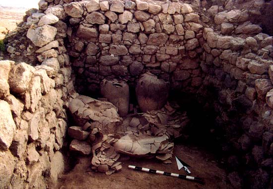
Walking through the central long room to the back of the building, we pass through a doorway into the room on the westernmost side of the house. This was almost completely filled with large, collared-rim pithoi (storage jars) lined up along the walls. Although empty when we found them, they would have been filled with grain and other foodstuffs for the family that lived in the house. (One pithos base found in the ruins contained barley grains.) The inhabitants subsisted mostly on what they themselves could grow, pasture, collect, hunt or catch. There was probably no formal, extensive market system in place. A bit of bartering with neighbors or with passing caravans for exchangeable necessities undoubtedly took place, but most food for survival probably came from the family’s own production system. They must have attempted to fill up their storage jars every year. Standing over three feet tall, each jar could contain several bushels of grain. Here and elsewhere on the site we found piles of carbonized barley and broad bean, chickpea, grape, lentil and green bean remains.
The scattered remains of approximately 20 more pithoi were found on top of the ones in situ. These probably fell from the second story when the house was destroyed.
Based on the finds on the ground floor, we assume the family ate, slept and entertained on the second floor. This conclusion is also supported by the finds that fell from the second floor and now cover the first-floor debris- a huge basalt lower millstone, which must have taken several strong men to lift; a loaf-shaped basalt upper millstone; a beautiful basalt tripod bowl; some basalt ballistica (that may have been reused as pounders for crushing herbs and spices); a few overturned pithoi; a small ceramic jar; domestic animal bones; and even an imported alabaster bowl.
A few textile implements, such as ceramic and stone spindle whorls of several sizes and loom weights, suggest that spinning and sewing also took place on the second floor.
The family no doubt slept on mats and covered themselves with blankets; we found no such remains, however, as the material would have been biodegradable.
We must assume yet one more living area—the roof. Most likely encircled by a low parapet of mudbrick (see Deuteronomy 22-8) and partially roofed with mud and clay, the open area would have served as a place for sleeping or resting in the summer (see Joshua 2-8; Judges 3-20; 1 Samuel 9-25–26). Perhaps laundry, washed at the spring at the foot of the northern slope of the town, was hung over the parapet to dry.
Among the destruction debris we also found a 3-foot-long cylindrical stone roof roller. Before and after the winter and spring rains, the roller would be used to consolidate and reseal the roof lest water leak through cracks in the drying mud.
East of the four-room house was a partially open courtyard with a paved enclosure that measured 9 by 14 feet. The paved area was probably used for stabling small animals or cattle. Above the pavement we found food-preparation utensils such as grindstones, textile implements, a jar handle with an abstract seal impression, a basalt stone weight, a sandstone bead and, intriguingly, the feet, legs and mounting peg of a bronze human figurine. Do these finds represent human activities in the enclosure? Or could they have tumbled from the second story of the house as it collapsed toward the east? We’re not sure.
A few feet east of this complex we uncovered a huge trash pit, roughly oval in shape, 14 feet long, 9 feet across and 8 feet deep. Because of the prevailing westerly winds, the pit was downwind of the house; periodically the contents would have been burned. Here we found fragments of objects for textile operations, food preparation and storage, cosmetic application, and recreation (gaming pieces). In addition, there were 4,700 ceramic sherds and over 15,000 animal bone fragments. Of nearly 2,300 bone fragments studied thus far by Joris Peters of the Institut für Paläoanatomie in Munich, Germany, over 85 percent are from sheep and goats, and nearly 11 percent are from cattle; the remaining bones are from pigs, horses, donkeys and dogs. Not all these bones necessarily came from animals that were eaten, however. The presence or absence of pig bones, we believe, is not a strong ethnic marker because we have no means of knowing precisely how early or extensively followed the cleanliness laws outlined in Leviticus 11 were, and most Semitic tribal peoples probably followed similar dietary customs and taboos. We do not believe the presence of pig bones precludes an Israelite (or better, proto-Israelite, to use William Dever’s term) identification.
Building A, which is to the south of Building B and once shared a common stone wall with it, has not yet been completely uncovered, but enough has been found to tell us that it was nearly as large as Building B. It, too, had two stories, with the second floor, like the top story of its neighbor, constructed of sun-baked mudbricks plastered over for utilitarian and aesthetic reasons. But while similarities existed between the two houses, there were also significant differences.
For example, while Building B had only the remains of a stone-ringed hearth in the northernmost room, a more complete cooking area was found in a corner of a large room on the north side of Building A. Nearby was a pie-shaped, stone-lined storage bin over 3 feet in diameter and with edges standing 12 to 15 inches high. A cooking hearth was found in the middle of the room.
More importantly, in the center of a stone-paved room to the west was a large, flat-topped boulder, somewhat deeper than it was wide, oriented east-west. This was placed directly in front of a 3-foot-high standing stone found in situ against the western wall. Both of these stones were naturally smoothed and shaped (unlike the stones in the walls), suggesting that they were specially selected, perhaps from a cave where water could have given them their shape and texture. Standing stones usually indicate sacred areas and may symbolize a deity; the flat boulder in Building A might have served as an altar for votive offerings in front of the standing stone. Mixed in with the fallen debris from the second story were several items often found in shrines, including three chalices, a cup and saucer, and, much more rare, a pair of small bronze hand cymbals, each about 4 inches in diameter. In 1 Samuel 10-5 a band of prophets plays musical instruments as they prophesy. Could our cymbals have accompanied some religious ceremony?
In the Bible a man named Micah builds a household shrine dedicated to Yahweh, which might have been much like the one we uncovered at ‘Umayri. As the text tells us, “In those days … every one did as he pleased” (Judges 17-6). There was no central political authority to enforce uniform religious laws.
West of the shrine was a broad room that contained about seven more collared pithoi. Although we cannot be certain, the two adjacent broad rooms of Buildings A and B, built directly against the site’s western perimeter wall, might have served an additional purpose- If hostile forces planned to attack and the town’s citizens sniffed out the plan in advance, they could fill the rooms with dirt and thereby broaden the perimeter wall from 7 or 8 feet to about 16 feet. The fears of the inhabitants that their town might be attacked, as reflected in their extensive defenses, proved well founded.
In a lightning-quick military slam into the hilltop settlement, an unidentified force blitzed the place and burned it to the ground, forcing the occupants to make a quick retreat from their houses and to generally abandon the town. They did not have time or, indeed, may not have survived in sufficient numbers to return for the huge amounts of stored grain that lay buried beneath the bricks of the destruction. These piles of grain, complete with insect pests (beetles), suggest an early summer assault, after the barley harvest but before the wheat harvest.
Bronze lance and arrow points, along with scattered sling stones, found mostly in the broad room of Building B, testify to the nature of the attack. So do the burned, disarticulated bones of two men. They may have died while fighting on the roof or the second story; their bones then tumbled with the collapse of the second story, splaying upon impact with the pithoi stored on the ground floor.
The fire that burned the city must have been very hot. It not only consumed the wooden support posts and beams of the houses, but, fueled by the stores of wood and straw, it scorched the white limestone walls to a dark gray and turned some stones to lime powder. The carbonized barley grains were so hard from the intense heat that we needed a hammer to break them.
The pottery discovered in ‘Umayri dates to the late 13th or early 12th century B.C.E. This is at least as old as and probably slightly older than the very earliest of the unwalled settlements west of the Jordan, which most scholars identify as early Israelite (or proto-Israelite). This then fits one of the predictions we made from Cross’s hypothesis- Settlements belonging to Reuben should precede settlements in other areas of the Israelite confederation.
Add to this the fact that no other highland site west of the Jordan from approximately this time was as large or as prosperous as ‘Umayri. This strongly hints that the corollary prediction is also true, namely, that Reuben should be the most prosperous tribe, befitting its hypothesized leadership role.
The third prediction—if Cross’s hypothesis is correct—is that we should find a cluster of sites, not just one, since we are identifying a tribal area rather than a single city. And several contemporaneous sites, including Tall Hisban, Tall Jalul, Tall Jawa and Tall Madaba, have indeed been recently excavated in the region immediately south and east of ‘Umayri.6 These sites are within about 12 miles of each other (Madaba to Jawa) and even within sight of one another. And all these sites—most of which were dug by teams related to ours—have produced finds similar to those of ‘Umayri, although so far not with the same excellent state of preservation or clarity of exposure. But they do represent a cluster of sites, which may fit the Reubenite hypothesis.
The small finds from ‘Umayri are similar not only to the finds from these neighboring sites, but also to finds from the earliest highland sites west of the Jordan River, especially those in the Shechem area, long considered the central territory of the earliest Israelite tribal confederation. These include identical potters’ marks on jar handles, a type of crude seal, very similar pottery and similar numbers of pottery types.7
Could ‘Umayri have belonged to a people other than the Reubenites? Possibly, but not probably.
Perhaps ‘Umayri could have been Ammonite- It’s located only 10 miles south of the ancient site of Rabbat Ammon. As yet, however, no significant contemporaneous sites have been found around Amman any closer than ‘Umayri (although two small, isolated sites exist north of Amman). Even Amman itself has, so far, not produced clear remains that could be as early as the finds from ‘Umayri. Only toward the end of the 12th century B.C.E. do we have evidence of burgeoning Ammonite towns, especially at Sahab, about five miles southeast of the ancient site of Amman. But by that time ‘Umayri had already been destroyed and abandoned.
Could ‘Umayri have been Moabite? Most likely not. Recent evidence shows that the Moabites did not begin to settle their central territory south of the Arnon River (Wadi Mujib) until about a century after ‘Umayri’s destruction. There is as yet no published Moabite site clearly dated to early Iron Age I.
Could ‘Umayri have been Amorite? This is difficult to answer, because just who the Amorites were archaeologically is unclear. And if ‘Umayri was Canaanite, the site should have finds similar to those at sites in the Jordan Valley. But those sites, with their wider range of ceramic types and relatively more frequent imported items, had a very different character from ‘Umayri.
We draw no conclusions with absolute certainty, but it seems likely that our cluster of settlements in Transjordan was limited to the region of the Madaba Plain; is earlier than other clusters of Iron Age I settlements in the immediate Ammonite region and in Moab; and was associated most closely with similar, possibly slightly later, sites west of the Jordan usually identified with the tribal confederacy known as Israel.
That the finds at ‘Umayri and nearby sites are thus related to finds west of the Jordan and that there is a lack of contemporaneous finds east of the Jordan in Ammon and Moab seem to confirm the Reubenite hypothesis as outlined by Cross. But they do not prove it. The evidence is only circumstantial, and there are still too many unknowns to be sure. No other hypothesis, however, is better supported—so far.
Regardless of who settled the ‘Umayri region, archaeologists need to revise their generalized views of how the tribal groups of Israel, Ammon and Moab settled in the Holy Land. Tribal relationships are characterized by fluidity; they rise and fall, and loyalties are swapped.8 The Song of Deborah (Judges 5) illustrates the fluidity of this early period very well- It mentions only 10 tribes in the Israelite confederation, one of which (Machir) is not in later lists of the 12 tribes. At the risk of making an extremely complex process overly simple, we can summarize the political and social processes from Iron Age I (1200–1000 B.C.E.) into Iron Age II (beginning about 1000 B.C.E.) this way- As tribal relationships and loyalties became more consistent and less fluid through time, groups of allied tribes arose and slowly grew into nations or territorial states and monarchies.
If we may identify ‘Umayri and related sites in the region as Reubenite, the settlement process of that tribe probably began as early as the 13th century B.C.E., growing to include the prosperous walled town at ‘Umayri and possibly other sites as well.
At the same time or a little later, other highland tribes were beginning to settle in smaller, less developed, unwalled villages west of the Jordan. These other tribal groups may have confederated with or under Reuben and called their confederation “Israel.” Later, leadership of the confederation passed to one of the tribes west of the Jordan, leaving Transjordan to the Ammonites, the Moabites and a few remaining Israelites (the Moabite king Mesha mentions their presence in the Madaba region in his mid-ninth century B.C.E. stele).
So who destroyed ‘Umayri so thoroughly? It could have been the Ammonites to the north, other tribal groups or even the Egyptians under Pharaoh Merneptah (who, in his 1207 B.C.E. stele, refers to Israel as a group of peoples rather than as a city, thus fitting a tribal confederation). Or the prosperous Reubenites may have blocked their hypothesized Midianite patrons from trading along the King’s Highway, thus incurring their wrath.
Whatever the ultimate answers to our questions, Tall al-‘Umayri is opening a new chapter in our discussion of the world of the early Biblical period.
a. See “Frank Moore Cross—An Interview, Part I- Israelite Origins,” Bible Review, August 1992; and Allen Kerkeslager, “Mt. Sinai—In Arabia?” Bible Review, April 2000.
1. New official spellings of all sites in Jordan now correspond to the Arabic spellings of the written words, not the Arabic pronunciations of the spoken words; thus, the word for an ancient mound, tell, has become tall; it is, however, pronounced exactly the same as tell! ‘Umayri’s spelling was also changed from ‘Umeiri.
2. The Madaba Plains Project (MPP) excavates three sites—‘Umayri is sponsored by LaSierra University in consortium with Canadian University College and Walla Walla College and in association with Andrews University. MPP also includes excavations at Tall Hisban and Tall Jalul, both sponsored by Andrews University.
3. The roots of this plant were apparently an aphrodisiac. See Hector Avalos, “Ancient Medicine- In Case of Emergency, Contact Your Local Prophet,” Bible Review, June 1995, p. 30.
4. Frank Moore Cross, “Reuben, First-Born of Jacob,” Zeitschrift für die altestestamentliche Wissenschaft 100, Supplement (1988) pp. 25–37. This article was called to Herr’s attention by Larry Stager of Harvard University. Cross has published a revised version of this article, “Reuben, the Firstborn of Jacob- Sacral Traditions and Early Israelite History,” in From Epic to Canon- History and Literature in Ancient Israel (Baltimore- Johns Hopkins Univ., 1998), pp. 53–70. For a more technical report covering the same material as the present article, see Larry G. Herr, “Tall al-‘Umayri and the Reubenite Hypothesis,” Eretz Israel 26 (Cross Volume, 1999), pp. 64–77.
5. The evidence for the earthquake is very clear- collapsed slabs of bedrock and rapidly deposited fills in open fissures in the ground.
6. Tall Hisban was the first site excavated by the Madaba Plains Project and was directed by Siegfried Horn and Lawrence Geraty in the 1970s. It is now being excavated by Øystein LaBianca and Paul Ray. The excavation of Tall Jalul, another MPP site, is directed by Randall Younker and David Merling. The dig at Tall Jawa, begun by MPP under Randall Younker, was directed by Michèle Daviau after the first season until its recent completion. The excavations at Tall Madaba are directed by Timothy Harrison, who dug at ‘Umayri for several seasons.
7. For the upside-down V-shaped potter’s mark, see Adam Zertal, “An Early Iron Age Cultic Site on Mount Ebal- Excavation Season 1982–1987,” Tel Aviv 13–14 (1986–1987), fig. 19-11. For the crude seals with abstract designs, see B. Brandl, “Two Scarabs and a Trapezoidal Seal from Mount Ebal,” Tel Aviv 13–14 (1986–1987), fig. 1-2.
Subscribe
If you enjoyed this article, subscribe to receive more just like it.


Thank you so much for such a fantastic post.
I saw your publications previously, however this one I think about
the ideal. How can you find so many details? I enjoy
how that you organize everything, since it’s truly simple to read.
All in all, I can recommend this article to everyone who is interested in that subject.